Guararema
| Guararema | ||
|---|---|---|
|
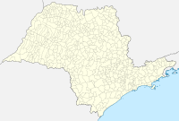
Coordinates: 23 ° 25 ′ S , 46 ° 2 ′ W Guararema on the map of Sao Paulo
|
||
|
Location of the municipality of Guararema in the state of São Paulo
|
||
| Basic data | ||
| Country | Brazil | |
| State | São Paulo | |
| City foundation | September 19, 1899 | |
| Residents | 25,844 (IBGE / 2010) | |
| City insignia | ||
| Detailed data | ||
| surface | 270.496 | |
| height | 585 m | |
| Time zone | UTC −3 | |
| City Presidency | Adriano de Toledo Leite ( PR ) | |
| Website | ||
| Church in Guararama | ||
Guararema is a Brazilian city in the southeast of the state of São Paulo . A 2010 census showed a population of 25,844 people. According to official estimates, around 29,451 people lived in Guararema in 2018. Guararema is located on the Rio Paraíba do Sul .
Individual evidence
- ↑ IBGE on Guararema. Retrieved May 25, 2019 .
Web links
- Website (portuguese)


