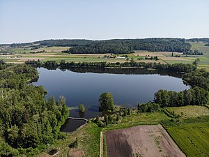
Hüttwilersee
| Hüttwilersee | ||
|---|---|---|

|
||
| Hüttwilersee from the south | ||
| Geographical location | Canton of Thurgau | |
| Tributaries | Seegrabe (from Nussbaumersee ) and canal from Hasensee | |
| Drain | Seebach | |
| Places on the shore | Hüttwilen , Uesslingen-Buch | |
| Data | ||
| Coordinates | 705 517 / 274 201 | |
|
|
||
| Altitude above sea level | 434 m above sea level M. | |
| surface | 34 ha | |
| length | 1.25 km | |
| width | 580 m | |
|
particularities |
Nature reserve |
|
The Hüttwilersee , formerly also Steineggersee, is located in the Seebachtal in the canton of Thurgau in Switzerland , on the border of the communities Hüttwilen and Uesslingen-Buch at 434 m above sea level. M. There is a lido on the eastern bank.
The Hüttwilersee is close to the Nussbaumersee and Hasensee lakes . Originally the area around the three lakes was a moorland with little forest. In the cultivation battle of the Second World War , the water level of the lakes was lowered by around 1.5 m and the bank areas were drained so that the surrounding area could be used for agriculture. As a result, the water condition of the lake deteriorated noticeably. The Seebachtal Foundation was established in 1994 with the aim of preserving the near-natural cultural landscape in the area of the Seebachtal lakes.


