Haga (Gothenburg)
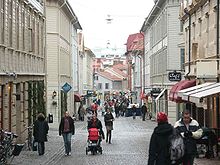
Haga is a neighborhood in the Swedish city of Gothenburg . It is known for its picturesque wooden houses and 19th century style cafes. Originally a suburb for the working class with a bad reputation, Haga gradually developed into a popular spot for tourists and locals alike. During the 1980s, the quarter was completely renovated. The houses were either renovated or demolished and replaced with postmodern replicas.
Today, around 4,000 people live in Haga, a hundred years ago it was 15,000, an indicator of the gentrification process that the district has gone through. Haga is also a parish with the same boundaries as the neighborhood. In terms of area, it is the smallest parish in Sweden.
history
The quarter was built in the middle of the 17th century at the behest of Queen Christina . Haga became Gothenburg's first suburb. Originally it was decreed that the area could be destroyed in the event that the land was needed by the Crown or in the event of a city siege, as the district was outside the city walls. In the 1690s this order was applied and 34 houses were demolished to create a sheltered passage, a caponier , from the city wall to Skansen Kronan fortress .
It was not until the 1840s that new industries established themselves in Gothenburg, which led to an influx of workers and made Haga the first working-class neighborhood in the area. This led to a housing shortage during the 1870s and the establishment of more working-class neighborhoods to cope with the rapid population growth. After expanding the area extensively, the population began to decline in the 1920s. Many businesses were closed and Haga became a residential area.
A new development plan in 1962 called for the demolition of the old buildings in the district. This led to the founding of the Haga Group in 1970, which campaigned for the preservation of the original architecture. Between 1973 and 1977 demolition work decreased due to local resistance and some buildings were even renovated by local authorities.
Coordinates: 57 ° 41 '52.6 " N , 11 ° 57' 21.1" E
