Halin
Halin (also Halingyi - Great Halin ) was the third largest city of the Pyu people , who lived in what is now Myanmar (Burma) in the first millennium AD .
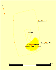
Halin was on the west bank of the Irrawaddy in the area of today's Sagaing Division, northwest of the city of Mandalay . The city was 3 × 1.5 km in size and surrounded by a brick wall. Inside the city complex was a walled palace complex. Numerous urns, some inscriptions and statues have been found during excavations. Only a few architectural remains were found, which is due to the fact that wood was the main building material. The city flourished mainly from the 2nd to the 6th centuries. It was destroyed in 832 by the Kingdom of Nánzhāo .
Various inscriptions came to light during excavations, some naming kings and queens. Among them are King Sri Trivigrama and King Ruba.
Excavations took place here from 1904 to 1905, 1929 to 1930 and 1963 to 1967.
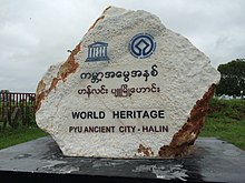
In 1996 it was proposed to raise the city with other places of the Pyu to the world cultural heritage of the UNESCO. In 2014 Halin was added to the World Heritage List together with Sri Ksetra and Beikthano-myo under the name Historic Cities of the Pyu .
Web links
Individual evidence
- ↑ Elizabeth H. Moore: Early Landscapes of Myanmar. Tatien 2007, ISBN 9749863313 , p. 184.
Coordinates: 22 ° 29 ' N , 95 ° 51' E


