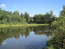
Hall ponds
The Hall Ponds are a group of ponds in Sonneberg State Forest, Woods "bee", about 500 meters east of the district Rottmar the community Föritztal .
history
Already before 1800 the first fish ponds were created by dikes and flooding of "acid meadows". The majority of the ponds near Oberlind and Rottmar owe their origin to the flourishing brick industry in the Sonneberg area in the late 19th century. Even before 1830, a brick factory was in operation on the outskirts of Oberlind. After the Sonneberg town fire (around 1840), the demand for brickwork products increased suddenly.
In a radius of 5 kilometers around the town of Rottmar, as early as 1880, 5 brick factories can be identified that exploited the high-quality clay deposits available on site for their production. Another 50 mostly small or channel-like pits and mining fields were created during railway and road construction (for railway embankments) and for sand extraction (possibly also special sands for glassworks). After the brickworks were closed, some of the deep pits, which had already been flooded by groundwater, became fish ponds, while the majority of the higher-lying mining fields were affected by reforestation or leveling.
Renaturation
In September 2009 the lower Hall pond (near the sports field) in Rottmar was renatured . For this purpose, the water was desludged, the pond floor was sealed with a layer of mineral clay and a new drainage regulation was introduced. Since then the pond has been carrying water all year round and rare animal and plant species have settled again.
In the summer months, the lower hall pond often has no fresh water supply. The inflow has often dried up for several months. This means that the pond has a very low water level.
fauna
The only breeding occurrence of the pygmy moorhen ( Porzana pusilla ) in Thuringia was mentioned in 1912 by Oskar Tellgmann (1852–1920) in the hall ponds.
Individual evidence
- ^ G. Brückner: Landeskunde des Herzogthums Meinigen , Volume 2: The topography of the country , Verlag Brückner and Renner, Meinigen 1853, p. 449 f.
- ↑ Steinindustrie-Schotterwerke GmbH & Co. KG - Reference list hydraulic engineering 2002 to 2011 ( page no longer available , search in web archives ) Info: The link was automatically marked as defective. Please check the link according to the instructions and then remove this notice. (PDF, 7 MB)
- ↑ Errors and confusions with the small rale species Porzana parva and Porzana pusilla , especially in Thuringia (PDF; 152 kB), Anzeiger des Verein Thüringer Ornithologen 7, 69–84. December 2010
Coordinates: 50 ° 19 ′ 44 ″ N , 11 ° 13 ′ 6 ″ E

