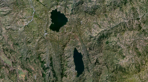
Hardibo Lake
| Hardibo Lake | ||
|---|---|---|

|
||
| The Hardibo lake (below) with the Hayksee (above) satellite photo | ||
| Geographical location | Amhara ; Ethiopia | |
| Drain | Stream towards the north at Biriti in the Hayksee | |
| Places on the shore | Biriti | |
| Location close to the shore | Haik | |
| Data | ||
| Coordinates | 11 ° 14 ′ 0 ″ N , 39 ° 46 ′ 0 ″ E | |
|
|
||
| Altitude above sea level | 2133 m | |
| surface | 14.9 km² | |
| length | 8.3 km | |
| width | 2.5 km | |
| Maximum depth | 64 m | |
The Hardibo Lake ( Amharic ሃርዲቦ ሐይቅ , hardibo häyq ) or Ardibbo is a freshwater lake in Ethiopia that is drawn in a north-south direction . It is located north of Dese in the Debub Wollo (Däbub Wällo Zonə) zone of the (or kilil ) Amhara region . The city of Biriti lies on its northeastern bank. The Hardibo lake is 8.3 kilometers long and 2.5 kilometers wide with an area of 14.9 km² and is located at an altitude of 2,133 meters above sea level.
Individual evidence
- ↑ Water Resources and Irrigation Development in Ethiopia - IWMI ( Memento of the original from July 18, 2011 in the Internet Archive ) Info: The archive link has been inserted automatically and has not yet been checked. Please check the original and archive link according to the instructions and then remove this notice. (PDF; 701 kB)
