
Hexengang (Osnabrück)
| Witch gang Klapperhagen
|
|
|---|---|
|
|
|
 |
|
| Hexengang with a view to the end of the Great Cathedral Freedom | |
| Basic data | |
| city | Osnabrück |
| district | Downtown |
| Connecting roads | Conrad-Bäumer-Weg |
| Places | Great freedom of the cathedral |
| Buildings | Osnabrück Cathedral , small church , Carolinum grammar school |
| use | |
| User groups | pedestrian |
| Road design | Bricks |
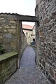
The Hexengang or Klapperhagen is a narrow alley by the cathedral in Osnabrück . It leads from the Great Cathedral Freedom between the Small Church and the Cathedral. On the last piece towards the rabbit there is a building above the alley, so that it ends from a small portal on the street Conrad-Bäumer-Weg. Due to the high walls that surround the alley, the corridor appears very dark and oppressive.
The street was probably only given the name Hexengang in the 19th century, when it was assumed that the women who were held as witches in Bucksturm in the 16th and 17th centuries were led to the hare by the witches' walk to test water . This assumption is, however, refuted, since the witch walk belongs to the area of the Catholic cathedral, but the witch hunt was carried out by the evangelical magistrate of the city.
The original name Klapperhagen is based on the prohibition that people who were sick with leprosy or the plague were not allowed to enter the cathedral. Here on the cathedral facade, however, they were allowed to take part in the service, but had to warn themselves with a ratchet .
gallery

Portal at the "Conrad-Bäumer-Weg"
At the "Little Church"

View into the Hexengang from the east

Entrance area at the "Great Cathedral Freedom"


Web links
Individual evidence
- ↑ https://www.noz.de/deutschland-welt/niedersachsen/artikel/517539/sgonaunken-hexen-und-der-teufel#gallery&0&0&517539 In Neuer Osnabrücker Zeitung on October 27, 2014: "Sgönaunken, Hexen und der Teufel" ; accessed on October 4, 2018
- ↑ https://www.noz.de/lokales/osnabrueck/artikel/610313/der-dom-in-osnabruck-wurde-auf-einer-insel-gebaut In Neuer Osnabrücker Zeitung on August 27, 2015: "Der Dom in Osnabrück was built on an island "; accessed on October 4, 2018
Coordinates: 52 ° 16 '39.7 " N , 8 ° 2' 44.2" E