
Hiba Dōgo Taishaku Quasi National Park
|
Hiba Dōgo Taishaku Quasi National Park
|
||
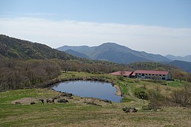
 Mountains Ikenodan (left), Tateeboshi (center) and Hiba (back right) seen from the southeast |
||
| location | Tottori Prefecture , Shimane Prefecture and Hiroshima Prefecture , Japan | |
| surface | 84.16 km² | |
| WDPA ID | 3267 | |
| Geographical location | 35 ° 4 ' N , 133 ° 14' E | |
|
||
| Setup date | July 24, 1963 | |
| administration | Tottori Prefecture , Shimane Prefecture and Hiroshima Prefecture | |

The Hiba Dōgo Taishaku Quasi National Park ( Japanese 比 j 道 後 帝 釈 国 定 公園 , Hiba dōgo taishaku kokutei kōen ) is one of over 50 quasi national parks in Japan. The prefectures of Tottori , Shimane and Hiroshima are responsible for the management of the park. The park was founded on July 24, 1963 and covers an area of approx. 85 km². With the IUCN Category V, the park area is classified as a Protected Landscape / Protected Marine Area .

Landmarks
- Mount Hiba ( 比 婆 山, Hibayama ): 1,299 m
- Mountain Dōgo ( 道 後 山, Dōgoyama ): 1,271 m
- Mount Azuma ( 吾 妻 山, Azumayama ): 1,240 m
- Mount Sentsū ( 船 通 山, Sentsūzan ): 1,142 m
- Taishaku Valley ( 帝 釈 峡, Taishaku-kyō ): approx. 20 km long
- Shinryū Lake ( 神 竜 湖; Shinryū ko )
Flora and fauna
The park area is covered with primeval forests in which one can find Japanese beeches, oaks and horse chestnuts . The fauna includes collar bears , Japanese macaques , crested eagles and the Japanese giant salamander .
gallery
Hut on Mount Azuma

Onbashi ( 雄 橋 )

Taishakugawa Dam


