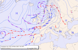
High-over-low location
In a high-over-low position is a high pressure area , instead of the Iceland lows , over the territory of Iceland , while over the Azores , instead of the Azores high , a low pressure system storage.
This is a very unusual location and usually only occurs in winter . If the west drift and thus the NAO index is weak, such a situation can arise. One then speaks of a reversal or a blocking . The following general weather situation is usually a low in southwest Europe or over the Bay of Biscay . Often polar or Siberian cold then reaches the central European area .

|
High-over-low location November 23, 2017: Storm low Ylva fixed off Scandinavia, an extensive Azores high offshoot Zoe in the Mediterranean area; the Azores high had also formed a high pressure wedge over Greenland into the North Pole area, and retreated westward into the Caribbean, while low pressure areas advance from the Central Atlantic towards south-western Europe. Extreme turbulence of the jet stream and the polar front . The NOAA-NAO index peaked at −1.2 on the 21st, the AO index at −3.6. 26.-28. a similar situation.
|
literature
- Davini P., Cagnazzo C., Neale R., Tribbia J.: Coupling between Greenland blocking and the North Atlantic Oscillation pattern. In: Geophys. Res. Lett. 2012, doi : 10.1029 / 2012GL052315
Individual evidence
-
↑ Forecast for Thursday, November 23, 2017, 12:00 UTC , DWD weather map;
Weather situation as of November 23, 2017, 12 UTC. ZAMG Current weather map and map archive ;
NCEP, November 23, 2017, 7:00 p.m. locale. meteociel.fr (especially Jet stream 300 HPa (Hem. Nord) ). - ↑ Forecast for Monday, November 27th, 2017, 12:00 UTC , DWD weather map; Weather situation as of November 27, 2017, 12 UTC. ZAMG Current weather map and map archive ; NCEP, November 27, 2017, 7:00 p.m. locale. meteociel.fr.