Polar front

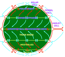
In meteorology, a polar front is understood to be the boundary area between the oppositely flowing air masses of polar cold air and subtropical warm air .
In contrast to the weather-effective fronts of the low pressure areas , the polar front separates two main air masses of the atmospheric body at approximately 60 ° latitude, which is why it is also referred to as the climatic front . It is not designed as a uniform belt, but shifts with the large-scale different advance of polar and warm air masses to the south and north in so-called Rossby waves . As a turbulence zone, the polar front is the area of origin of the dynamic low-pressure areas that strongly determine the weather in the higher central latitudes .

The waves of the polar front jet stream, which largely determines the weather in the northern hemisphere , have shifted less strongly in the recent past than in the past. This creates heat waves , especially in Europe, Japan and the western United States.
See also
- Arctic front
- Frontal zone
- North Atlantic Oscillation Index (NAO), a measure of the turbulence in the polar front
Web links
Individual evidence
- ↑ Heat due to high winds: is the jet stream running out of breath? Retrieved August 5, 2019 .