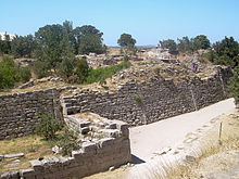
Hisarlık Tepe
Coordinates: 39 ° 57 ′ 26 ″ N , 26 ° 14 ′ 19 ″ E
Hisarlık Tepe (' palace hill ') refers to the archaeological site of the castle hill of Troy in Turkey west of Tevfikiye , Çanakkale province . In science, Hisarlık is equated with Troy.
From Hisarlık Tepe, the Aegean Sea is 6.5 kilometers and the Dardanelles about 7 kilometers away.
The approximately 15-meter-high hill contains at least twelve layers of settlement that date from a period of at least 3500 years. The last of these dates from Roman times .
Heinrich Schliemann discovered Priam's treasure on May 31, 1873 on Hisarlık Tepe , but due to the time context it cannot be assigned to the mythical King Priam . Schliemann announced in 1873 to the public that he had found Troy with Hisarlık Tepe.
Web links
Individual evidence
- ↑ A. Molia, A. Richard: Troja - On the trail of a myth. In: YouTube.com. Retrieved July 9, 2020 . Documentation, France 2016 (arte), 26 min.
- ↑ K. Kris Hirst: Ancient Troy's Possible Location in Hisarlik. In: archeology.about.com. October 12, 2015, accessed July 9, 2020 .


