
Çanakkale (Province)
| Çanakkale | |
|---|---|
| Province number: | 17th |
  |
|
| Counties | |
 |
|
| Basic data | |
| Coordinates: | 40 ° 2 ′ N , 26 ° 34 ′ E |
| Provincial capital: | Çanakkale (city) |
| Region: | Marmara region |
| Surface: | 9,817 km² |
| Population: | 540,662 (2018) |
| Population density: | 52 inhabitants / km² |
| Political | |
| Governor: | Orhan Tavlı |
| Seats in Parliament: | 4th |
| Structural | |
| Telephone code: | 0286 |
| Features : | 17th |
| Website | |
| www.canakkale.gov.tr (Turkish) | |
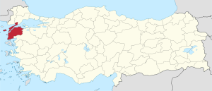
Çanakkale is a province of Turkey . Its capital is the city of Çanakkale .
The province stretches across the Gelibolu peninsula in Eastern European Thrace to Asia Minor , which are separated from each other by the Dardanelles (Çanakkale Boğazı) . It belongs to the Marmara region . The European part borders the provinces Edirne and Tekirdağ in the north , the Asian part borders the province Balıkesir in the southeast .
The province also includes the islands of Gökçeada (Imbros) and Bozcaada (Tenedos). The Battle of Gallipoli took place on the Gelibolu peninsula .
population
Results of the population extrapolation
The following table shows the annual population development at the end of the year after updating by the addressable population register (ADNKS) introduced in 2007. In addition, the population growth rate and are gender relations ( sex ratio h. Number of women per 1,000 men d.) Listed.
The 2011 census determined 489,298 inhabitants, around 24,000 more than in the 2000 census.
| year | Population at the end of the year | Population growth rate (in%) |
Gender ratio (women per 1000 men) |
Rank (among 81 provinces) |
||
|---|---|---|---|---|---|---|
| total | male | Female | ||||
| 2018 | 540,662 | 273.092 | 267,570 | 1.93 | 980 | 39 |
| 2017 | 530.417 | 269.160 | 261.257 | 2.04 | 971 | 40 |
| 2016 | 519.793 | 262,288 | 257.505 | 1.26 | 982 | 42 |
| 2015 | 513.341 | 259.721 | 253,620 | 0.30 | 977 | 41 |
| 2014 | 511.790 | 259,655 | 252.135 | 1.88 | 971 | 41 |
| 2013 | 502,328 | 254,800 | 247,528 | 1.75 | 971 | 41 |
| 2012 | 493,691 | 250,633 | 243.058 | 1.49 | 970 | 41 |
| 2011 | 486.445 | 249,088 | 237.357 | −0.81 | 953 | 41 |
| 2010 | 490.397 | 254,579 | 235.818 | 2.65 | 926 | 41 |
| 2009 | 477.735 | 243,643 | 234.092 | 0.62 | 961 | 42 |
| 2008 | 474.791 | 242,471 | 232.320 | −0.28 | 958 | 42 |
| 2007 | 476.128 | 244,613 | 231,515 | - | 946 | 41 |
| 2000 1 | 464.975 | 215,571 | 249,404 | 1157 | 43 | |
1 2000 census
Census results
The following tables show the population of Çanakkale province documented in the 14 censuses .
The values in the table on the left are taken from e-books (from the original documents), the values in the table on the right come from the data query of the Turkish statistical institute TÜIK - available on this website:
| year | population | rank | |
|---|---|---|---|
| province | Turkey | ||
| 1927 | 181.735 | 13,648,270 | 35 |
| 1935 | 222,792 | 16.158.018 | 37 |
| 1940 | 304,588 | 17,820,950 | 24 |
| 1945 | 317.254 | 18,790,174 | 23 |
| 1950 | 289,429 | 20,947,188 | 36 |
| 1955 | 311,456 | 24,064,763 | 36 |
| 1960 | 337.610 | 27,754,820 | 38 |
| year | population | rank | |
|---|---|---|---|
| province | Turkey | ||
| 1965 | 350.317 | 31,391,421 | 39 |
| 1970 | 360.764 | 35.605.176 | 42 |
| 1975 | 369.385 | 40,347,719 | 44 |
| 1980 | 391,568 | 44,736,957 | 44 |
| 1985 | 417.121 | 50,664,458 | 46 |
| 1990 | 432.263 | 56.473.035 | 45 |
| 2000 | 464.975 | 67,803,927 | 43 |
Number of provinces in relation to the census years:
- 1927, 1940 to 1950: 63 provinces
- 1935: 57 provinces
- 1955: 67 provinces
- 1960 to 1985: 73 provinces
- 1990: 73 provinces
- 2000: 81 provinces
Administrative division
The province of Çanakkale is divided into twelve districts :
| district | Area 1 (km²) |
Population (2018) 2 | Number of Units | Density (Ew / km²) |
urban share (in%) |
Gender ratio 3 |
Founding date 4.5 |
|||
|---|---|---|---|---|---|---|---|---|---|---|
| district | Administrative headquarters (Merkez) |
Municipalities (Belediye) |
District (Mahalle) |
Villages (Köy) |
||||||
| Ayvacık | 880 | 33,568 | 8,881 | 2 | 6th | 64 | 38.15 | 56.38 | 999 | 06/01/1928 |
| Bayramiç | 1,204 | 29,716 | 15,338 | 1 | 4th | 75 | 24.68 | 51.62 | 1019 | |
| Biga | 1.310 | 90,576 | 54,429 | 3 | 14th | 108 | 69.14 | 65.64 | 1002 | |
| Bozcaada | 37 | 3,023 | 3,023 | 1 | 2 | 1 | 81.70 | 0.00 | 794 | |
| Çan | 905 | 48.215 | 30,072 | 2 | 9 | 65 | 53.28 | 66.17 | 993 | 08/01/1945 |
| Eceabat | 430 | 8912 | 5,679 | 1 | 2 | 12 | 20.73 | 63.72 | 968 | |
| Ezine | 727 | 32.003 | 14,232 | 2 | 7th | 49 | 44.02 | 56.02 | 955 | |
| Gelibolu | 823 | 44,809 | 30,341 | 3 | 10 | 26th | 54.45 | 78.82 | 853 | 06/26/1926 |
| Gokceada | 282 | 9,783 | 7.205 | 1 | 5 | 9 | 34.69 | 73.65 | 716 | |
| Lapseki | 821 | 27,327 | 13,126 | 3 | 6th | 40 | 33.29 | 70.31 | 1001 | |
| Merkez | 1,016 | 180.823 | 136.002 | 2 | 10 | 52 | 177.98 | 90.72 | 1003 | |
| Yenice | 1,381 | 31,907 | 7,698 | 2 | 6th | 76 | 23.10 | 31.53 | 1023 | 06/15/1936 |
| PROVINCE Çanakkale | 9,817 | 540,662 | 23 | 81 | 577 | 55.07 | 71.22 | 980 | ||
swell
1 area in 2014
two population projection on December 31, 2018
3 sex ratio (Sex Ratio): Number of women per 1000 men (calculated)
4 PDF file of the Interior Ministry
five counties, the first to have been formed Foundation of Turkey (1923).
Attractions
In the province, to which the ancient landscape of Troas also belongs, there are several sights:
- the Historical National Park Troy with the ancient city of Troy
- the ancient city of Assos
- in the ancient place Chryse the temple of Apollon Smintheus
- the ancient city of Alexandria Troas
- the westernmost point of mainland Asia Minor in Babakale , the ancient Hamaxitos
- the Çanakkale Archaeological Museum , in which finds from Troy and other parts of Troy are exhibited
- On the Gelibolu peninsula in the European part of the province there are various memorials that commemorate the fighting during the First World War ( Gelibolu Peninsula Historical National Park with the Çanakkale Şehitleri Anıtı monument )
Web links
Individual evidence
- ↑ Türkiye Nüfusu İl ve İlçelere Göre Nüfus Bilgileri , accessed on June 1, 2019
- ↑ Portrait of the governor on the website of Çanakkale Province , accessed on June 1, 2019
- ↑ Genel Nüfus Sayımları (census results 1965 to 2000)
- ↑ Directorate General of Mapping PDF file 0.25 MB
- ↑ Türkiye Nüfusu İl İlçe Mahalle Köy Nüfusu , accessed on June 1, 2019
- ↑ [1] TARİH (1) .pdf 1.4 MB
Adana | Adıyaman | Afyonkarahisar | Ağrı | Aksaray | Amasya | Ankara | Antalya | Ardahan | Artvin | Aydın | Balıkesir | Bartın | Batman | Bayburt | Bilecik | Bing oil | Bitlis | Bolu | Burdur | Bursa | Çanakkale | Çankırı | Çorum | Denizli | Diyarbakır | Düzce | Edirne | Elazığ | Erzincan | Erzurum | Eskişehir | Gaziantep | Giresun | Gümüşhane | Hakkâri | Hatay | Iğdır | Isparta | İstanbul | İzmir | Kahramanmaraş | Karabük | Karaman | Kars | Kastamonu | Kayseri | Kırıkkale | Kırklareli | Kırşehir | Kilis | Kocaeli | Konya | Kutahya | Malatya | Manisa | Mardin | Mersin | Muğla | Muş | Nevşehir | Niğde | Ordu | Osmaniye | Rize | Sakarya | Samsun | Siirt | Sinop | Sivas | Şanlıurfa | Şırnak | Tekirdağ | Tokat | Trabzon | Tunceli | Usak | Van | Yalova | Yozgat | Zonguldak