Ağrı (Province)
| Ağrı | |
|---|---|
| Province number: | 04 |
| Counties | |
| Basic data | |
| Coordinates: | 39 ° 34 ' N , 43 ° 13' E |
| Provincial capital: | Ağrı |
| Region: | Eastern Anatolia |
| Surface: | 11,099 km² |
| Population: | 539,657 (2018) |
| Population density: | 49 inhabitants / km² |
| Political | |
| Governor: | Suleyman Elba |
| Seats in Parliament: | 4th |
| Structural | |
| Telephone code: | 0472 |
| Features : | 04 |
| Website | |
| www.agri.gov.tr (Turkish) | |
Ağrı ( Armenian Աղրի , Kurdish Agirî ) is a province in the far east of Turkey .
Their capital is also called Ağrı . At the time of the Ottomans the city was called Şarbulak , which means "flowing spring". In 1927 the name was changed to Karaköse , which goes back either to the Ottoman conqueror in 1507 Karagöz Bey or to Kara Kilise (German: "black church"). Since 1938 the city and province have been named after Mount Ararat ( Ağrı Dağı ).
geography
The province of Ağrı borders on Iran to the east, the provinces of Kars and Iğdır to the north, the provinces of Muş and Erzurum to the west, and the provinces of Van and Bitlis to the south . The province of Ağrı has an area of 11,376 km² and almost half consists of mountains. The Great Ararat ( Büyük Ağrı Dağı ) is the highest mountain in Turkey at 5137 m. The province owes its name to him. Big Ararat's little brother is Little Ararat ( Küçük Ağrı Dağı ) (3896 m). Other high mountains are the Süphan Dağı (4058 m), the Aşağı Dağı (3270 m), the Karadağ Dağı (3243 m) and the Aladağ Dağı (3250 m). The most important lake in the province of Ağrı is the 2241 m high Balık Gölü ("fish lake").
history
Ağrı is at the junction between the Caucasus , Asia Minor and Iran . There are traces of the Hittites , the Hurrites and the Urartians (cf. Anzavurtepe ). The Urartians had made the area around the neighboring Lake Van the center of their culture. The Cimmerians also held their own here for a while (archaeological traces are missing, however) until the area came under the rule of the Medes , who died around 550 BC. Were ousted by the Persians . 200 years later, Alexander the Great conquered this area. After Alexander's death at the latest, the Armenians settled in this area and have survived to the present. After centuries of alternating rule, Agrı came under the rule of the Seljuks in 1071 AD . From this point onwards, Turkmen and Turks were present here. In the 16th century, Ağrı was conquered by the Ottomans . Ağrı became the scene of the Ottomans' wars against the Persians and Russians. During the First World War , Ağrı was occupied by the Russians and only evacuated in 1920. Ağrı has been part of Turkey since 1923. Between 1927 and 1930 there were several Kurdish uprisings, some of which were organized by the Xoybûn ( Ararat uprising ). Turkey was only able to end the uprising after moving the border in consultation with Iran. In the 1980s there was also fighting between the army and the PKK here .
In 1920 part of the province of Erzurum was split off and became an independent province under the name Bayazıt. In November 1926 Karaköse was renamed provincial capital and in 1938 city and province in Ağrı.
Attractions

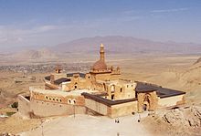
In addition to the Ararat, the Bagavan Armenian monastery complex and the İshak Paşa Palace are the province's greatest attractions.
population
In 2018, Ağrı Province had a population of 539,657. Until the genocide of the Armenians from 1915 and the genocide of the Arameans in 1916, many Armenians and Arameans lived in Ağrı . Today's population consists of Kurds , Turks , Azeris and Circassians .
economy
In 2017, the gross domestic product per capita was 12,729 lira (approx. 3000 euros). This made Ağrı the poorest province in the country.
Administrative division
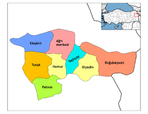
The province of Ağrı consists of the counties:
| district | Area (km²) 1 |
Population (2018) 2 | Number of Units | Density (Ew / km²) |
urban share (in%) |
Gender ratio 3 |
Founding date 4.5 |
|||
|---|---|---|---|---|---|---|---|---|---|---|
| district | Administrative headquarters (Merkez) |
Municipalities (Belediye) |
District (Mahalle) |
Villages (Köy) |
||||||
| Diyadin | 1,351 | 42.123 | 20,190 | 1 | 7th | 62 | 31.18 | 47.93 | 917 | |
| Dogubeyazıt | 2,250 | 121.263 | 79,493 | 1 | 14th | 85 | 53.89 | 65.55 | 896 | |
| Eleşkirt | 1,307 | 34,180 | 10,537 | 4th | 20th | 55 | 26.15 | 49.01 | 929 | |
| Hamur | 873 | 19,115 | 3,456 | 1 | 4th | 45 | 21.90 | 18.08 | 917 | 04/01/1958 |
| Merkez Ağrı | 1,695 | 149.188 | 115.285 | 1 | 18th | 106 | 88.02 | 77.27 | 952 | |
| Patnos | 1,394 | 122,833 | 62.106 | 2 | 25th | 92 | 88.12 | 53.55 | 898 | 04/01/1936 |
| Taşlıçay | 822 | 20,450 | 6,729 | 1 | 4th | 37 | 24.88 | 32.90 | 953 | 06/01/1954 |
| Tutak | 1,407 | 30.505 | 6,747 | 1 | 5 | 80 | 21.68 | 22.12 | 944 | |
| Ağrı PROVINCE | 11,099 | 539.657 | 12 | 97 | 562 | 48.62 | 58.26 | 921 | ||
swell
1 area in 2014
two population projection on December 31, 2018
3 sex ratio (Sex Ratio): Number of women per 1000 men (calculated)
4 PDF file of the Interior Ministry
five counties, the first to have been formed Foundation of Turkey (1923).
population
The following table shows the annual population development at the end of the year after updating by the addressable population register (ADNKS) introduced in 2007. In addition, the population growth rate and are gender relations ( sex ratio h. Number of women per 1,000 men d.) Listed.
The 2011 census identified 553,241 inhabitants, which is almost 25,000 more than the 2000 census.
| year | Population at the end of the year | Population growth rate (in%) |
Gender ratio (women per 1000 men) |
Rank (among 81 provinces) |
||
|---|---|---|---|---|---|---|
| total | male | Female | ||||
| 2018 | 539.657 | 280.923 | 258.734 | 0.63 | 921 | 40 |
| 2017 | 536.285 | 277.979 | 258.306 | -1.10 | 929 | 39 |
| 2016 | 542.255 | 281,389 | 260,866 | -0.91 | 927 | 39 |
| 2015 | 547.210 | 284.243 | 262,967 | -0.40 | 925 | 39 |
| 2014 | 549.435 | 285,449 | 263,986 | -0.32 | 925 | 39 |
| 2013 | 551.177 | 286.161 | 265.016 | -0.22 | 926 | 38 |
| 2012 | 552,404 | 287,490 | 264.914 | -0.55 | 921 | 38 |
| 2011 | 555.479 | 291,340 | 264.139 | 2.48 | 907 | 38 |
| 2010 | 542.022 | 280,518 | 261.504 | 0.81 | 932 | 38 |
| 2009 | 537.665 | 280,000 | 257,665 | 1.03 | 920 | 39 |
| 2008 | 532.180 | 276.508 | 255.672 | 0.25 | 925 | 39 |
| 2007 | 530,879 | 275.243 | 255.636 | - | 929 | 39 |
| 2000 1 | 528.744 | 273,895 | 254,849 | 930 | 40 | |
1 2000 census
Census results
The following tables show the population of the province of Ağrı 1 documented in the 14 censuses .
The values in the table on the left are taken from e-books (from the original documents), the values in the table on the right come from the data query of the Turkish statistical institute TÜIK - available on this website:
| year | population | rank | |
|---|---|---|---|
| province | Turkey | ||
| 1927 | 57,177 | 13,648,270 | 56 |
| 1935 | 107.206 | 16.158.018 | 56 |
| 1940 | 121,477 | 17,820,950 | 56 |
| 1945 | 133.504 | 18,790,174 | 56 |
| 1950 | 155,455 | 20,947,188 | 55 |
| 1955 | 185.928 | 24,064,763 | 55 |
| 1960 | 215.116 | 27,754,820 | 55 |
| year | population | rank | |
|---|---|---|---|
| province | Turkey | ||
| 1965 | 246.961 | 31,391,421 | 56 |
| 1970 | 290.311 | 35.605.176 | 51 |
| 1975 | 330.201 | 40,347,719 | 48 |
| 1980 | 368.009 | 44,736,957 | 45 |
| 1985 | 421.131 | 50,664,458 | 45 |
| 1990 | 437.093 | 56.473.035 | 43 |
| 2000 | 528.744 | 67,803,927 | 40 |
1 In 1927 the province was still called Bayazit.
Number of provinces in relation to the census years:
- 1927, 1940 to 1950: 63 provinces
- 1935: 57 provinces
- 1955: 67 provinces
- 1960 to 1985: 73 provinces
- 1990: 73 provinces
- 2000: 81 provinces
Personalities
- İhsan Aksoy , Turkish and Kurdish speaking author
- Nizamettin Ariç , singer and director
Web links
Individual evidence
- ↑ Directorate General of Mapping 2014 , accessed May 5, 2019
- ↑ Türkiye Nüfusu İl ve İlçelere Göre Nüfus Bilgileri , accessed on May 5, 2019
- ^ Portrait of the governor on the provincial page
- ↑ .. :: Welcome to Turkish Statistical Institute (TurkStat) 's Web Pages :: .. Retrieved January 13, 2019 .
- ↑ Directorate General of Mapping PDF file 0.25 MB
- ↑ Türkiye Nüfusu İl İlçe Mahalle Köy Nüfusu , accessed on May 5, 2019
- ↑ [1] TARİH (1) .pdf 1.4 MB
- ↑ Genel Nüfus Sayımları (census results 1965 to 2000)


