
Eastern Anatolia

Eastern Anatolia ( Turkish Doğu Anadolu ) is the largest in terms of area and the smallest in terms of population of the seven geographic areas of Turkey . With an area of 163,000 km², the region represents around 20.9 percent of the Turkish state territory . The official name is Doğu Anadolu Bölgesi ("East Anatolia Area").
This region has officially existed since the First Turkish Congress of Geographers in Ankara in 1941 and is geographically divided into four subregions or areas.
Classification
Geographically
The geographical division:
- Anatolia
- Eastern Anatolia
- Erzurum-Kars Bölümü - area Erzurum - Kars
- Yukarı Fırat bölümü - Upper Euphrates area
- Yukarı Murat-Van Bölümü - Upper Murat area - Van
- Hakkari Bölümü - Hakkari area
- Eastern Anatolia
Politically
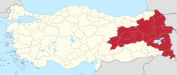
Politically, Turkey is divided into 81 provinces. The Eastern Anatolia Region includes the following provinces:
| Parliamentary election 2018 results from Eastern Anatolia | ||||
|---|---|---|---|---|
| Political party | percent | |||
| Adalet ve Kalkınma Partisi | 42.3% | |||
| Halkların Democracy Partisi | 32.3% | |||
| Milliyetçi Hareket Partisi | 10.2% | |||
| Cumhuriyet Halk Partisi | 8.5% | |||
| Otherwise. | 6.7% | |||
climate
| Climatic data of Eastern Anatolia | numbers |
|---|---|
| Average temperature | 9.7 ° C |
| Maximum temperature | 47.4 ° C |
| Lowest temperature | −40.6 ° C |
| Average humidity | 60.9 mg |
| Average rainfall | 569.0 mm |
geography
Eastern Anatolia borders the Black Sea region , Central Anatolia , the Mediterranean region , Southeast Anatolia as well as Georgia , Armenia , Nakhchivan / Azerbaijan , Iran and Iraq . The average altitude is around 2000 m. The highest mountains in Turkey are in this region, such as B. the Ararat with 5137 m , the Uludoruk in the Cilobergen with 4135 m and the Süphan Dağı with 4058 m .
population
According to the 2000 census, the population is 6,137,414 and the population density is 37.7 inh / km² (TR nationwide: 88.25 in / km²). 53.05% (3,255,896) of the population live in cities and 46.95% (2,881,518) in rural areas. The annual population growth is 1.375%.
Sights and landscapes


Ağrı : Ağrı is 1640 m above sea level on the transit route to Iran. According to legend, are the remains of Noah's Ark today on the Ararathochland located 5137 m high mountain Ağrı (Ararat) is that it attracts adventurers and over again.
The most magnificent building in East Anatolia, the Ishak Pasha Palace , is located near the city of Doğubeyazıt . Opposite the palace is a fortress built by the Urartians. The actual fortress was built in 1380 by Prince Beyazıt and got its name from him. In the Diyadin district there are thermal baths known as the 'Pamukkale of Eastern Anatolia'.
Bingöl : The city and province of Bingöl (Turkish "thousand lakes") were named after a glacial lake in this area. In the northern part of the province there are many mountain and glacier lakes that have emerged from the ice melt . Bingöl-Yolçatı is a popular ski resort. There areseveral thermal springs and baths in the province. Most of the city's buildings are new as it was destroyed in the 1971 earthquake disaster.
Bitlis : The Bitlis province, located on a plateau, is one of the most important tobacco growing areas in Turkey. Ahlat , an old cultural and art center from the Middle Ages,is located on the shores of Lake Van. The Seljuk cemetery in Ahlat is one of the great art wonders of the world at that time. The picturesque Tatvan, on the other hand, is located in the west of Lake Van and has a harbor that is well protected from the winds.
Erzincan : The historical sights of the city of Erzincan weredestroyedby an earthquake in1939. The Urartean settlement of Altıntepe from the first millennium BC is located a few kilometers east of Erzincan. In Tercan youcan see the Mama Hatun-Kümbeti tomb and the Mama Hatun Hanı caravanserai from the 13th century. Kemah owns a fortress. In addition to the orchards and vineyards, the art of copper processing also gained regional popularity. The Karaparmak grape variety is grown in this province, which is surrounded by mountain ranges in the north and south.
Hakkâri : Hakkari is the most mountainous province of Turkey, where characteristics of the "four seasons at once" can be seen. Many mountains in this province are covered with snow / ice all year round, so there are also several glacial lakes. The "Cilo Sat Mountains" and the "Zap Valley" provide a beautiful panoramic view and are visited by mountaineers. The “Melikesat Medresse” in the center of Hakkari ,built in the 15th century,is the city's most important historical building.
Malatya : The province is located on a fertile plain, where different types of fruit have been grown for centuries. TheMalatya apricots are well known in Turkey. In the city of Battalgazi, named after the popular hero Battal Gazi, there is still a historic city complex. The Roman Emperor Titus had the city's fortress built in the 1st century AD. However, it wasthoroughly restoredby the Seljuks in the 12th century. Another building from the Seljuk-Turkish period is the Battalgazi Ulu-Camii , the only mosque in Anatolia whose plan is based on a pillared hall. The archaeological excavation site Arslantepe (Turkish "lion's hill")is locatedbetween Battalgazi and Malatya .
Muş : The province of Muş is one of the most interesting areas of Turkey both in terms of its economic position and its natural beauties. It occupies an important place in the history of the Turks . In Malazgirt the Turks won the Battle of Manzikert and “manifested” their existence in Anatolia. The sights of the city are the fortress ofMus, the monastery of Surp Karabet (Çengel Church), the Great Mosque (Ulu Camii), the mosques of Haci Seref and Alaeddin Bey and the caravanserai of Aslanlı. Time and again there were clashes between Sunnis and Alevis in Mus. The Sunnis make up the largest religious group in Muş with more than 80%, ahead of the Alevis (approx. 12%). There are also a few Yazidi villages in the east of the province.
Tunceli : The landscape of this province is rich in pristine flora and fauna. Many of the world's endangered silver birch trees can be found in Munzur Valley Park. The history of Tunceli goes back to the Hittites. Buildings, fortresses, monuments, mosques and columns from Assyrian, Seljuk and Ottoman times have been preserved to this day. The city is famous for its colored with natural dyes Kelime their "Dersim" mentioned colorful wool socks and chewing gum thistle roots known.
Van : The city of Van is located on the southeastern shore of Lake Van (Van Gölü), the largest lake in Turkey. The city with its old name " Tušpa " (pronounced Tuschpa) was around 1000 BC. The capital of the Urartu Empire . In the 9th century BC King Sarduri I had the "Fortress of Van" built, which is 1800 m long and 120 m wide and is 80 m above the water level of Lake Van.
The city is also particularly known for its natural-colored kilims , the distinctive silver handicraft, the Vankatzen with their different colored eyes and the large lake, which is 1720 m above sea level. The island with the most flora is the Akdamar .
literature
- Volker Eid : In the land of Ararat . Peoples and cultures in Eastern Anatolia. Darmstadt, Wissenschaftliche Buchgesellschaft, 2006, ISBN 3-534-18206-5 .
- Michael Zick: Turkey. Cradle of civilization. Konrad Theiss, Stuttgart 2008, ISBN 978-3-8062-2110-7 .