
Aegean Region (Turkey)

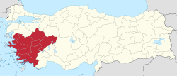
The Turkish Aegean region (named after the Aegean ) is the fifth largest of the seven geographic areas of Turkey with an area of 79,000 km² . The official name is "Ege area" (tr. Ege Bölgesi ). It represents about 10.1% of the Turkish state territory and borders on Central Anatolia , the Marmara and Mediterranean regions . This region is also known as the Turkish Aegean Sea .
This region officially exists after the Geography Congress in Ankara in 1941 and is divided into two further subregions or areas.
Classification
Geographically
The geographical division:
- Anatolia
- Aegean region
- Asıl Ege Bölümü - area of the real Aegean / Ege
- İçbatı Anadolu Bölümü - Inner area to Anatolia
- Aegean region
Politically
| Parliamentary election 2018 results from Aegean region | ||||
|---|---|---|---|---|
| Political party | percent | |||
| Adalet ve Kalkınma Partisi | 35.5% | |||
| Cumhuriyet Halk Partisi | 33.4% | |||
| İyi Parti | 12.9% | |||
| Milliyetçi Hareket Partisi | 8.8% | |||
| Otherwise. | 9.4% | |||
Politically, Turkey is divided into 81 provinces. This region includes the following provinces:
Climate data
| Climate data of the Aegean region | numbers |
|---|---|
| Average temperature | 15.4 ° C |
| Maximum temperature | 48.5 ° C |
| Lowest temperature | −45.6 ° C |
| Average humidity | 60.9 mg |
| Average rainfall | 569 mm |
population
According to the census in 2000, the population is 8,938,781 and the population density is 113 inhabitants / km² (TR nationwide: 88.25 inhabitants / km²). 61.5% (5,495,575) of the population live in cities and 38.5% (3,443,206) in rural areas. The annual population growth is 1.629%.
economy
The Aegean region is the second largest industrial area in Turkey after the Marmara region. The region's electricity supply is provided by the thermal power plants in Soma, Tunçbilek and Yatağan and the hydropower plants in Kemer and Demirköprü.
In İzmir , the textile, food, automotive, petroleum and mechanical engineering industries as well as spare parts production predominate. The Çamaltı Salt Mine, the largest salt production facility in the country, is located in the Gulf of İzmir.
Most of the olive oil in the region is produced in Ayvalık and Edremit . There are several sugar factories in Afyon , Kütahya and Uşak , although there is also a sulfur factory in Kütahya.
The city of Denizli is the most important textile center in the region and exports most of its products abroad. Carpet weaving is particularly well represented in Demirci, Gördes, Kula, Simav and Uşak. There are significant deposits of marble in Afyon, so production facilities have been set up on site. Cotton weaving is widespread in Aydın , Denizli, İzmir, Nazilli and Uşak.