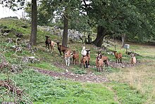
High stone (Rüthen)
The Hohe Stein is a rock formation on the course of the Lörmecke southwest of Kallenhardt , a district of Rüthen , and a landmark on the hiking trail along the Lörmecke. It is accessible via the A5 and A6 hiking trails of circular hiking trail system 13.
The limestone cliff is about 50 m high; a cone of rubble is in front of it. The originally higher mountain was removed by quarrying .
The area was less woody until the middle of the 20th century due to the goats . The goats belonged in particular to the breed of white German noble goat . Plant species represented include swallowweed , stemless thistle and cruciferous flowers . In order to preserve the habitat that has formed in this cultural landscape, the slope on the Hohen Stein has been grazed again since 2006. The goals are to reduce nutrient resources and keep trees free.
The rock formation is located in the Lörmecketal nature reserve and FFH area . The Hohler Stein is in the immediate vicinity .
Web links
Individual evidence
- ↑ http://www.kallenhardt.de/sites/default/files/files/250-flyer_fliesswege.pdf
- ↑ http://www.panoramio.com/photo/6084061
- ↑ http://www.naturpark-arnsberger-wald.de/natur/landschaftsphaenomene/117060100000001599.php
- ↑ http://www.fliesswege.de/index.php?cat=lebensraum_hoher_stein&station=1
- ↑ http://www.fliesswege.de/index.php?cat=historie_hoher_stein&station=1
- ^ "Lörmecketal" nature reserve with biotope worthy of protection identifier BK-4516-201 in the specialist information system of the State Office for Nature, Environment and Consumer Protection in North Rhine-Westphalia , accessed on February 23, 2017.
Coordinates: 51 ° 26 ′ 21.1 ″ N , 8 ° 23 ′ 45.6 ″ E

