Irsingener See
| Irsingener See | ||
|---|---|---|

|
||
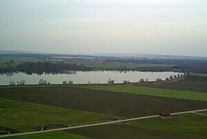
| Irsingener See from the southeast, Irsingen in the background | ||
| Geographical location | Between Bad Wörishofen and the Heisteig | |
| Tributaries | Wertach | |
| Drain | Wertach | |
| Data | ||
| Coordinates | 48 ° 1 '12 " N , 10 ° 39' 12" E | |
|
|
||
| Altitude above sea level | 617 m | |
| surface | 29 hectares | |
| length | 1.09 km | |
| width | 460 m | |
| volume | 1,500,000 m³ | |
The Irsingener See is a barrage of the Wertach southeast of Irsingen . The lake is in the area of the municipalities of Bad Wörishofen , Türkheim and Wiedergeltingen . There is a sailing club with a mooring on the west bank. The lake is dammed up by a power plant weir, which is used to generate electricity with two generators. Construction began in 1962, the lake was completed with the commissioning of the hydropower plant in 1964. Since 2011 there has been a fish ladder on the east side of the dam.
Surname
Occasionally the name Bad Wörishofener Stausee is used for this body of water .
See also
Individual evidence
- ↑ Federal Office for Cartography and Geodesy , State Office for Surveying and Geoinformation Bavaria : Digital Topographical Map 1:25 000, [1] , accessed on January 9, 2016
- ↑ Land use plan of the municipality of Wiedergeltingen from 2008
- ↑ a b Internet presence of the Bad Wörishofener sailing club
- ↑ mz: When more energy was needed in Bad Wörishofen. Augsburger Allgemeine, September 13, 2014, accessed on September 17, 2014 .
- ↑ Markus Heinrich: Fischtreppe lets the cash register ring. Augsburger Allgemeine, September 17, 2011, accessed January 15, 2012 .
- ↑ Internet presence of the Bad Wörishofen spa administration
