Irsingen (Türkheim)
|
Irsingen
Türkheim market
Coordinates: 48 ° 1 ′ 56 ″ N , 10 ° 38 ′ 21 ″ E
|
|
|---|---|
| Height : | 612 m above sea level NN |
| Residents : | 713 |
| Incorporation : | May 1, 1978 |
| Postal code : | 86842 |
| Area code : | 08245 |
|
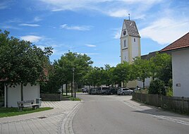
Center of Irsingen, St. Margareta Church
|
|
Irsingen is a district of the Türkheim market in the Unterallgäu district in Bavaria .
location
Irsingen is on the west bank of the Wertach . The main town of Türkheim is about three kilometers north of Irsingen. The Munich – Lindau A 96 motorway runs right on the outskirts .
history
The first documentary mention goes back to the year 1084. Irsingen had several main settlement areas early on. From the end of the 13th century, a distinction was made between Oberirsingen, today's capital, and Unterirsingen . Sometimes Unterirsingen was also referred to as Niederirsingen. Since the 18th century the term Irsingen without the prefix is only for the main town of the upper common. The Steingaden Monastery has acquired many properties in Irsingen over the centuries. In 1818 the place was made an independent municipality. This independence lasted 160 years until the regional reform in 1978, when Irsingen was incorporated into Türkheim.
Attractions
The parish church of St. Margareta is one of the local attractions.
Others
To the south-east of the village there is a barrage of the Wertach, which bears the name Irsingener See .
Web links
Individual evidence
- ↑ Federal Office for Cartography and Geodesy , State Office for Surveying and Geoinformation Bavaria : Digital Topographical Map 1:50 000, [1] , accessed on August 12, 2011.
- ^ Bavarian Academy of Sciences. Commission for Bavarian State History: Historical Book of Place Names of Bavaria: Swabia, Volume 8 , published by the Commission for Bavarian State History, 1989, page 60
- ↑ Historical review on the website of Markt Türkheim .
