Isla San Francisco
| San Francisco | ||
|---|---|---|
|
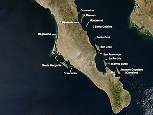
Satellite map with the islands in the south of the Gulf of California San Francisco roughly in the middle |
||
| Waters | Gulf of California | |
| Geographical location | 24 ° 49 '53 " N , 110 ° 34' 27" W | |
|
|
||
| length | 2.5 km | |
| surface | 3.778 km² | |
| Residents | uninhabited | |
Isla San Francisco is a Mexican island in the south of the Gulf of California . Administratively it belongs to the municipality ( municipio ) La Paz in the state of Baja California Sur ("Southern Baja California ").
geography
The island is located in the far north of the Bahía de La Paz , 2 km south of the much larger neighboring island of San José and a good 10 km east of the Baja California peninsula , from which it is separated by the Canal de San José . La Paz , the capital of the municipality and the state, is a good 100 km south of the island. Isla San Francisco is 2.5 km long, almost 3.8 km² in size and has a striking, hook-shaped peninsula in the southeast, whose shallow bay is a frequent destination for sailors. In the north of the island there is a 9 m high lighthouse. The island is uninhabited.
Web links
Individual evidence
- ↑ Sailing Directions (enroute), Pub. 153 (PDF (2.49 MB); English) (Accessed January 20, 2011)

