
Island of Stroma
| Island of Stroma | ||
|---|---|---|
 |
||
| Waters | Pentland Firth ( Atlantic Ocean ) | |
| Archipelago | British Islands | |
| Geographical location | 58 ° 40 '46 " N , 3 ° 7' 4" W | |
|
||
| length | 3.6 km | |
| width | 1.6 km | |
| surface | 3.75 km² | |
| Highest elevation | Cairn Hill 53 m |
|
| Residents | uninhabited | |
| main place | Uppertown (historical) | |
 |
||

The uninhabited Island of Stroma (norn: Straumey ), part of the Parish Canisbay in northeast Caithness, is located off the north coast of Scotland , three kilometers from the port of John o 'Groats in the Pentland Firth , which separates the Scottish mainland from the Orkney archipelago .

In 1901 375 people were still at home here. By the late 1940s, the number had dropped to 111. In 1947 a Yorkshire umbrella manufacturer bought the island and initially failed to sell it again as the population began to migrate. In 1956 only sixteen people, including the staff of a lighthouse, lived on Stroma. The last members of the Manson family left the island in 1961. The island has been uninhabited since the lighthouse was automated in 1996. Only sheep and cattle live on Stroma .
photos
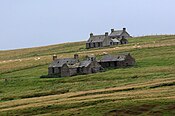
House ruins on Stroma
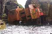
Wreck of the Bettina Danica

map


literature
- Donald A. Young: Stroma. Edinburgh 1992, ISBN 1871704073 .