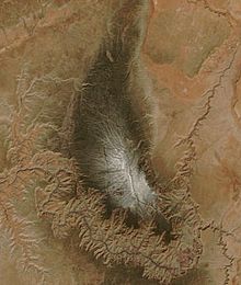
Kaibab plateau
The Kaibab Plateau is located in Coconino County in the US state of Arizona . The plateau is part of the Colorado Plateau . The extension of the plateau is about 95 kilometers in north-south and about 40 kilometers in west-east. The highest point of the plateau is 2805 meters above sea level .
Mining, grazing, forestry and tourism take place in the area.
location
The Kaibab Plateau is east of Las Vegas in northern Arizona. The plateau is bounded in the south by the Grand Canyon . There are steep rock faces and gorges to the west, south and east of the plateau, while the terrain slowly flattens out to the north. The southern part of the plateau is part of the Grand Canyon National Park. Most of the rest of the plateau is taken up by the Kaibab National Forest . The canyons that border the plateau were formed by the Colorado River and the Hualapai River.
climate
In winter, large parts of the plateau are covered with snow, with the highest parts of the plateau being covered by snow almost all year round. From May to early July, however, the climate is very dry. Again and again there are violent storms on the plateau.
Web links
Individual evidence
- ↑ Kaibab Plateau High Point - Peakbagger.com. Retrieved August 18, 2017 .
- ↑ Google Maps. Retrieved August 18, 2017 .
- ↑ Kaibab National Forest - Home. Retrieved August 18, 2017 .
- ^ Kaibab Plateau & North Rim Lookout: Climbing, Hiking & Mountaineering: SummitPost. Retrieved August 18, 2017 .
- ^ Bill Butler: The Kaibab Plateau and the Grand Canyon, Arizona. Retrieved August 18, 2017 .
- ↑ Irwin Rasmussen: Biotic Communities of Kaibab Plateau, Arizona .
Coordinates: 36 ° 25 ′ N , 112 ° 10 ′ W
