Kangerlussuaq (West Greenland)
| Kangerlussuaq Fjord | |
|---|---|
|
Head of the fjord with the airport north of the estuary |
|
| Waters | Davis Street |
| Land mass | Greenland |
| Geographical location | 66 ° 30 ′ N , 52 ° 7 ′ W |
| length | 170 km |
| Islands | Simiutaq |
| Tributaries | Russell Glacier |
|
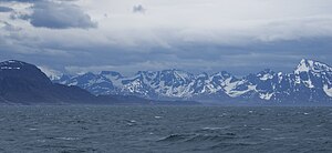
The mouth of the Kangerlussuaq Fjord photographed from the Davis Strait |
|
Kangerlussuaq ( Greenlandic language , in German: "long fjord"; Danish name: Søndre Strømfjord ) is a fjord in western Greenland that flows into the Davis Strait .
At the end of the fjord lies the uninhabited island of Simiutaq . The area of the fjord belongs to the Greenlandic municipality of Qeqqata Kommunia , whose administrative seat is Sisimiut . The 170 km long fjord is navigable along its entire length. The width is between 1.5 and 8 km. The Russell Glacier pushes from the inland ice towards Kangerlussuaq. Its meltwater and that of other glaciers feed a river in summer, the Qinnguata Kuussua ( Watson River ), whose estuary forms the head of the fjord.
The area was originally not permanently populated. The earliest human traces are 4000 year old sites of summer hunting camps of the Saqqaq culture . Today, at the head of the fjord, there is the community of 550 inhabitants , Kangerlussuaq , which has the same name as the fjord and has a port and an international airport, Kangerlussuaq Airport .
During World War II , the Americans occupied Greenland after Nazi Germany occupied Denmark , which included Greenland . At the head end of the Kangerlussuaq north of the river mouth, they built the large military airfield Bluie-8, which, with later extensions, forms the origin of today's Kangerlussuaq airport.
In the area around the fjord, tundra vegetation extends to the ice sheet , which also feeds thousands of reindeer and musk ox . The ice sheet is about 35 km away from the head of the fjord.
In 2012, the air in the area warmed up so much that the large amount of meltwater tore away the bridge over the river to the airport.
Web links
- Satellite image of the fjord and the wider area on the official Greenland tourism website; This is the fjord, at the end of which the place Kangerlussuaq is marked.
- Description of the area and location on the official tourism website. The site also allows you to listen to the Greenlandic pronunciation of the place name. de
- 360 degree panorama of the Russell Glacier
Individual evidence
- ↑ http://www.bridica.com/EBchecked/topic/554301/Kangerlussuaq
- ↑ https://www.youtube.com/watch?feature=player_embedded&v=kKjXKAatiIs
- ↑ http://www.greenland.com/de/explore-greenland/destination-arctic-circle/kangerlussuaq/trip-inspiration.aspx
- ↑ https://www.theguardian.com/environment/2012/jul/25/greenland-glacier-bridge-destroyed-video


