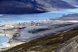
Kangerlussuaq Airport
| Airport Kangerlussuaq Mittarfik Kangerlussuaq Søndre Strømfjord Lufthavn |
|
|---|---|

|
|
| Characteristics | |
| ICAO code | BGSF |
| IATA code | SFJ |
| Coordinates | |
| Height above MSL | 50 m (164 ft ) |
| Basic data | |
| opening | 1941 |
| operator | Greenland Airport Authority ( Mittarfeqarfiit ) |
| Terminals | 1 |
| Passengers | 130,000 (2008) |
| Start-and runway | |
| 09/27 | 2810 m × 60 m asphalt |
The Kangerlussuaq Airport ( IATA: SFJ , ICAO: BGSF ) is the largest international airport in Greenland . He serves the region around Kangerlussuaq . The airport is also Air Greenland's largest hub . Up until the 1990s, the airport and city were called Søndre Strømfjord (and in the Danish language still today), hence the IATA code SFJ and the ICAO code BGSF.
Due to the sheltered location and the temperatures of just over zero degrees Celsius (average), the flight conditions at the airport are good, wide-body aircraft such as the Boeing 747 could land here.
Airlines and Destinations
Air Greenland flies to Aasiaat , Ilulissat , Kulusuk , Maniitsoq , Nuuk and Sisimiut in Greenland . There are also connections to the Danish capital in Copenhagen . The earlier flight to the USA to Baltimore has been removed from the flight schedule since March 2008. In addition to Kangerlussuaq, Air Iceland flies to five other destinations from Reykjavík Airport in Iceland with De Havilland DHC-8 .
history
The airport was on October 7, 1941 as US Army - Base founded and served as from 1952 Sondrestrom Air Base known. The military still uses this place as a strategic base today. The New York Air National Guard (NYANG) maintains a base here for Hercules machines that are equipped with skids for landing on the ice sheet. The goals are, for example, the research stations Camp Summit , Camp North Grip or Camp Raven , where survival training in the ice is also carried out for soldiers in the summer months.
Because of the shorter range of the aircraft in the 1960s and 1970s, the airport was also important for transatlantic traffic.
During the Berlin blockade in 1948/49, the airport was considered a transit station for the necessary food from the USA .
future
As a result of climate change, the permafrost is softening . As a result, the runway, taxiways and buildings get subsidence and cracks. The airport is therefore to be closed for commercial flights from 2024 (as of December 2019). As a replacement, the airports in Nuuk and Ilulissat will be renewed and expanded so that in future they will meet the standard for international airports and can also be used in poor visibility.
Web links
- Kangerlussuaq Airport on the website of the Greenland Airport Authority Mittarfeqarfiit (English, Danish, Greenlandic)
- Kangerlussuaq Airport on Air Greenland's website (English, Danish, Greenlandic)
- Maps of the airport ( Memento from April 18, 2010 in the Internet Archive )
- Airport data on World Aero Data ( 2006 )
Individual evidence
- ↑ List of commercial airports in North and Central America
- ↑ Kangerlussuaq. (pdf; 122 kB) AD 2 - BGSF - 3. (No longer available online.) In: AIP GREENLAND. Trafikstyrelsen / Danish Transport Authority, October 18, 2012, p. 3 , archived from the original on October 5, 2012 ; accessed on March 27, 2013 (English). Info: The archive link was inserted automatically and has not yet been checked. Please check the original and archive link according to the instructions and then remove this notice.
- ↑ Climate: Kangerlussuaq, Greenland allemetsat.com, accessed December 25, 2017 (English)
- ↑ Air Greenland closes route from Baltimore / Washington to Greenland fodors.com, accessed December 25, 2017 (English)
- ↑ Destinations Greenland airicelandconnect.com, accessed on December 25, 2017 (English)
- ↑ The drilling site of the North Greenland Ice Core Project (NGRIP or NorthGRIP) is near the center of Greenland (75.1 N, 42.32 W, 2917 m, ice thickness 3085).
- ^ Kangerlussuaq, Greenland to close within five years - report. ch-aviation, November 26, 2019.
- ↑ Greenland wants to boost tourism with new airports . PolarJournal, December 24, 2019
