
Kappelerhof

The Kappelerhof was a late medieval building and part of the city fortifications of the city of Zurich .
history
It was one of the oldest buildings in the scratching quarter and stood on the frogs' pit between the abbess tower and the scratching tower . The thick walls protruding several meters above the city wall and the representation on the Murer map from 1576 allow the assumption that in earlier times a tower also stood in its place. Nothing is known about the construction of the building. The Kappelerhof was first mentioned in a document in 1270, when it was called "House in the Ring Wall". In 1357 it was called «Kappelerhus», from 1408 «Kappelerhof».
It originally belonged to the Manesse family , who acquired it as an inheritance from the Fraumünster abbey. Hugo von Maness the Elder and his children sold it to the Altdorf pastor Burkhard. Burkhard donated the house to Kappel Monastery in 1270 , which already owned a house in 1223 on the "Lower Bridge".


The last two abbots, Ulrich Trinkler and Ulrich Wüest, carried out even greater renovations in 1492 and 1504. Ulrich Trinkler was forced to resign from office in 1508 due to insufficient administration, but stayed at the Kappelerhof. In 1511 he was executed, his successor was Ulrich Wüest. A carved piece of ceiling is now kept in the State Museum. At that time, the building is likely to have received the external form that Gerold Escher depicted around 1700. A bridge connected the first floor of the main building to the east with a small chapel.
In 1538, after the Reformation , the Kappelerhof first housed a boys' school, which had been relocated here from the Kappel Monastery, and in 1567 the "Office in the Kappelerhof" was established there, which administered the property of the former monastery. After 1576 the bailiff was appointed by the leading middle class families. The best-known official was Hans Conrad Gyger , the creator of the famous Gyger map from 1667.
With the beginning of the Helvetic Republic , the office in Kappelerhof was dissolved in 1798. In 1814 the rooms were used as a hospital for the Austrian army advancing through Switzerland to France. When the canton auctioned the building in 1833, the city of Zurich acquired it, which furnished rooms for administration and held meetings. After 1850 the characteristic stepped gables were removed, and in 1860 it was used again as a school.
In 1878 the Kappelerhof, like the scratching tower, had to give way to the continuation of Bahnhofstrasse from Paradeplatz to the lake. Today's square of houses began in 1879 on the site of the old Kappelerhof, at the corner of Bahnhofstrasse / Kappelergasse, and was closed in 1889 northeast of it at Kapplergasse 11. There was the house "To the traveling man", in which the executioner Peter Heiden lived around 1450.

The Kappelerhof from the east on a representation by Gerold Escher
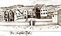
Kappelerhof from the west, 18th century

View into Kappelergasse towards Limmat, 1885
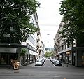
same place 2009


Kappelerkapelle
Behind the long side of the Kappelerhof stood the Kappelerhof chapel. It was separated from the main building by a narrow alley, and a covered corridor led from the gallery to the first floor of the office building. Gerold Escher recorded it in his depiction of the Kappelerhof around 1700. In 1509 the chapel with altar was rebuilt and consecrated to St. Mary by Vicar General Balthasar von Konstanz .
A square plaque in the ceiling of the chapel contained the year 1509 in the middle as well as the coats of arms of the Cistercians , the barons of Eschenbach as the founder of the Kappel monastery, the abbot Ulrich Wüest as the successor to Ulrich Trinkler and the coat of arms of the Kappel monastery itself Ceilings are owned by the Antiquarian Society and an altarpiece from the Marienkapelle, depicting the coronation of Mary, was housed in the Wasserkirche until the merger of the city library with the canton library ( Zurich Central Library ) in 1916 .
Individual evidence
- ^ Paul Nussberger: Old Zurich
- ^ Thomas Germann: Zurich in Time Lapse Volume I, Werd-Verlag Zurich, 1997
- ^ Helvetic Church History .
- ↑ Paul Guyer (Ed.): Pictures from old Zurich. Public buildings and guild houses based on drawings from around 1700. From Gerold Escher's regimental book . Publisher Hans Roth, Zurich 1954
- ^ Beat Haas, Thomas Meyer, Dölf Wild: Almost like in Paris. The redesign of the Kratzquartier around 1880, Zurich 2001
- ^ Fred Rihner: Illustrated history of the Zurich old town ; Bosch Verlag, Zurich 1975
- ^ Paul Nussberger: Old Zurich
literature
- Paul Guyer (Ed.): Pictures from old Zurich. Public buildings and guild houses based on drawings from around 1700. From Gerold Escher's regimental book . Publisher Hans Roth, Zurich 1954
- Thomas Germann: Zurich in Time Lapse , Volumes I and II, Werd-Verlag Zurich, 1997 and 2000
- Beat Haas, Thomas Meyer, Dölf Wild: Almost like in Paris. The redesign of the Kratzquartier around 1880 , Zurich 2001
- Walter Baumann: Zurich - Bahnhofstrasse Orell Füssli Verlag, Zurich 1972
- Hofer, Crispini, Baumann: Zurich, yesterday and today from the same perspective , Slatkine Verlag, Geneva 1984
- Paul Nussberger: Old Zurich . Groppengiesser Verlag, Zurich 1944
- Fred Rihner: Illustrated history of Zurich's old town ; Bosch Verlag, Zurich 1975
Coordinates: 47 ° 22 '7.5 " N , 8 ° 32' 24" E ; CH1903: 683 188 / 247017