
Frog pit


The Fröschengraben was a moat that belonged to the second fortification of the city of Zurich from the 12th and 13th centuries. It was built to strengthen the western city walls and filled in in 1864. In its place today is the Mittlere Bahnhofstrasse .
history
The irrigated ditch system with the inner frog ditch, the outer Sihl ditch and the wall in between appeared for the first time in the middle of the 13th century: a niuwer ditch is mentioned in 1258 and the ditch in Woloshofen Türlin in 1293 . Work was still being carried out on the outer ditch in 1300. Gardens were originally laid out on the ramparts, and a house is mentioned in 1346. The “Sprachhüsli”, a public toilet, stood in the area of the outer ditch around 1537. In the judge's letter , the wall was protected from interference.
The sludge that had accumulated over time was periodically shoveled out by day laborers or in bondage to work off fines. The excavated material was used as fertilizer on the meadows near Oetenbach Monastery .
course


The second city fortification and thus the course of the frogs' ditch is very well documented by several plans and contemporary illustrations, such as on the Murer plan . The frogs' pit began at the scratching tower at the height of today's intersection of Bahnhofstrasse and Börsenstrasse. For the time being, it ran parallel to the city wall in a northerly direction to the Rennweg bulwark , today the confluence of the Rennweg with Bahnhofstrasse. A wooden bridge was built near the Wollishoferturm in 1788. The bridge at the Augustinian bulwark had existed for a long time, as the main passage to the bridge at St. Jakob an der Sihl and the road to Baden was located there. The wooden bridge at the Rennwegtor was replaced by a stone bridge in 1789.
At the Rennwegtor the Fröschengraben turned to the northeast of the Limmat . The water fell through a sluice into a narrow ditch and flowed under the Oetenbachturm at the mills on Werdmühleplatz, where it merged with the “Zahmen Sihl” and flowed into the Limmat in front of the Oetenbach bulwark at the Gedeckten Brüggli . The purpose of the sluice was to prevent the water from the Sihl Canal in the Fröschengraben from backflowing , which merged with the Fröschengraben at the Werdmühlen.
Dimensions
In the south at the Kappelerhof the entire ditch system was 36 meters wide, at the Rennweg gate it was 42 meters. The frog pit alone was 20-24 meters wide, the watercourse 15 meters. In 1848 the depth of the entire trench at the Tiefenhöfe was 4.7 meters and at Rennweg 6 meters. The water depth was around 1.2 meters.

Rennweg Gate on the left, Augustinertor on the right

Bridge at the Wollishofertor

left Kappelerhof, right scratching tower
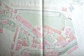
At the bottom left the Rennweg bulwark, at the bottom the Fröschengraben, to the left the underground junction of the Sihlgraben from the Sihlkanal. Situation plan 1860


The Sihlgraben or Äussere Graben
As can be clearly seen on old plans, two parallel trenches originally ran in front of the city wall, separated by a wall. The inner one, the actual frog pit, was fed by water from the lake and flowed north, the outer one was a southern arm of the "Zahmer Sihl". In the area of today's Jelmoli it branched off from the Sihl under the ground , joined the frogs' pit at the Rennwegtor and flowed in the opposite direction towards the lake. These separate systems served to relieve the Sihl during floods and to balance the water balance between Sihl and Lake Zurich. This "outer ditch" was covered by several wooden bridges, but over time it withered into a narrow trickle. In the area of today's Paradeplatz it was covered around 1720 between Bärengasse and Tiefenhöfen , which allowed the "New Market", today's Paradeplatz, to expand to the Fröschengraben. By 1800 the “Äusseren Graben” was completely filled.
The frog pit
A weak gradient, seeping sea mud and debris from the sewers of the city on the left bank meant that the frogs' pit turned into a foul-smelling swamp over time. At the beginning of the 18th century, the trench was first shoveled so that it could play its role in the defense system. 1814–1817 the trench was dug again, expanded and made navigable; Stone bank stairs were built in several places. It was possible to drive a Weidling from the lake to the Rennwegtor.
The wall between the two canals was a popular place for walks. It was first planted with willows, then with nut trees. The nut trees on the town of Grab en were ordered in a council ordinance for the special protection of the population. Lamp oil, which according to an old custom belonged to the water church , was pressed from the nuts . After the Reformation , the walnut trees were replaced by linden trees, of which the most famous, the Tiefenhof linden tree, was felled with great protest on March 25, 1857 when it was around 250 years old.
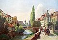
The frog pit 1860 on a drawing by Carl Toechi

Same view in 1864: The frogs' pit is filled in

The Tiefenhoflinde at Wollishofertor, view to the south

roughly the same location in 1855. On the left the hotel "Baur en Ville"


The end of the frog pit
When it became clear in 1854 that the station should remain at its previous location, the planning of the Bahnhofstrasse was started . In order to compensate for a reduction in water runoff, the Schanzengraben should be diverted into the Sihl instead of the Limmat. Construction work began at the beginning of May 1864. After a drainage channel had been drawn into the frogs' ditch for sewage from the city on the left bank, filling began in spring 1865. The channel was filled with gravel from the temporarily drained Schanzengraben and the road bed was created. Bahnhofstrasse was opened in autumn 1865 - the frogs' pit was history.
Individual evidence
- ↑ a b Christine Barraud Wiener, Peter Jezler: The City of Zurich I. City in front of the Wall, medieval fortifications and Limmatraum. Wiese Verlag, Basel 1999, p. 99f
- ^ A b c Walter Baumann: Zurich - Bahnhofstrasse, Orell Füssli Verlag, Zurich 1972
- ^ Thomas Germann: Zürich im Zeitraffer I, p. 40, Werd Verlag, Zürich 1997
literature
- Jürg Fierz (Ed.): Zurich - Who else is there? Orell Füssli Verlag, Zurich 1972.
- Walter Baumann: Zurich - Bahnhofstrasse , Orell Füssli Verlag, Zurich 1972.
- Thomas Germann: Zurich in Time Lapse , Volumes I and II, Werd-Verlag Zurich, 1997 and 2000.
- Christine Barraud Wiener, Peter Jezler: Art monuments of the Canton of Zurich; The city of Zurich I. City in front of the wall, medieval fortifications and the Limmatraum . Wiese Verlag, Basel 1999, p. 99f.