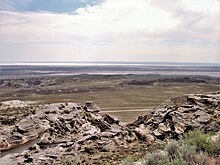
Karagije Depression
Coordinates: 43 ° 22 ′ 20.6 ″ N , 51 ° 49 ′ 15.6 ″ E
The Karagije Depression (also called Karagije Hollow , Kazakh Қарақия ойпаты, Qaraqiya oypatı ) contains the lowest point of Kazakhstan ( Central Asia ).
The deepest point of this depression , which is also the lowest point in the former Soviet Union , is 132 m below sea level . As part of the Aralo-Caspian Lowlands or the Caspian Depression , it is located southeast of Aktau and west of the Mangyshlak Plateau on the Mangghystau Peninsula, which protrudes into the Caspian Sea .
Web links
Commons : Karagiye - collection of images, videos and audio files

