Karanog
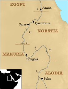
In the 2nd to 5th centuries AD, Karanog was a city north of the second cataract of the Nile in Lower Nubia , near the ancient city of Qasr Ibrim in modern-day Egypt , which today lies on the bottom of Lake Nasser . After the Meroitic rule it fell into the hands of the Blemmyes .
exploration
Beginning in 1907, the town was examined by D. Randall-Maciver and then by C. Leonard Woolley and his team in the second decade of the 20th century and documented for posterity.
The cemetery in particular brought rich finds. Many Meroitic inscriptions were found here, which suggest that the place was the seat of an official who perhaps represented something like the governor of Lower Nubia in Meroitic times.
literature
- F. Ll. Griffith : Karanòg. The Meroitic Inscriptions of Shablûl and Karanòg. University Museum, Philadelphia PA 1911 ( Eckley B. Coxe Junior Expedition to Nubia 6), catalog of the inscriptions, dictionary, image copies from the handwritten original reports and excavation photos (English), online at archive.org .
- C. Leonard Woolley : Karanòg. The Town. University Museum, Philadelphia PA 1911 ( Eckley B. Coxe Junior Expedition to Nubia 5), online at archive.org .
