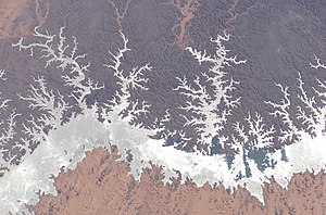
Lake Nasser
| Lake Nasser | |||||||||
|---|---|---|---|---|---|---|---|---|---|
| Lake Nasser | |||||||||
|
|||||||||
|
|
|||||||||
| Coordinates | 22 ° 25 ′ 12 ″ N , 31 ° 45 ′ 0 ″ E | ||||||||
| Data on the structure | |||||||||
| Data on the reservoir | |||||||||
| Altitude (at congestion destination ) | 183 m | ||||||||
| Water surface | 5 250 km² | ||||||||
| Reservoir length | 500 km | ||||||||
| Reservoir width | 35 km | ||||||||
| Maximum depth | 70 m (mean depth 25 m) | ||||||||
The Nassersee ( Arabic بحيرة ناصر, DMG Buḥairat Nāṣir ), named after the former Egyptian President Gamal Abdel Nasser , is the one in Egypt by the dam as-Sadd al-ʿĀlī (السدّ العاليAs, Aswan High Dam known) in the Nile Valley resulting dam , the south of Aswan lies. Part of the lake is located in Sudan , at Wadi Halfa , where it is called Nubia Lake .
The lake is around 500 km long, of which 350 km is accounted for by Lake Nasser and 150 km by Lake Nubia. It is between 5 and 35 km wide and contains about 165 km³ of water .
History and description
The lake was created in order to store sufficient amounts of water with which a period of low water, as it is expected to occur on a statistical average once every hundred years, could be bridged and thereby Egypt could be saved from immense damage.
The volume of the lake formed by the older Aswan dam was barely sufficient to maintain irrigation for Egyptian agriculture during the regular low water period of the respective year. Even a particularly low flood in the Nile would have led to major crop failures. Two or even more years of low water levels - events that have occurred again and again since Pharaonic times - would have had catastrophic consequences for the agriculture and the population of Egypt.
Harold Edwin Hurst determined the necessary storage volume with 37 km³ for irrigation during one year, 90 km³ for storage (Century Storage) and 30 km³ provision for sedimentation losses. The total volume was later expanded by a further 6 km³ to a total of 163 km³.
Already Muhammad Ali Pasha (1805-1848 Viceroy of Egypt) had begun to irrigation methods on the Nile switch from the traditional seasonal irrigation in flood basins to a perennial canal irrigation, thereby enabling several harvests per year. The Nile mud became less and less important in the ever-expanding systems of irrigation canals. When designing Lake Nasser, it was therefore accepted that the Nile mud would settle in the lake and that the farmers would have to use more mineral fertilizers .
The filling of the reservoir began in 1964; by 1976 the lake had reached the intended water level. During the extreme drought from 1984 to 1985 a discharge of more than 53 km³ per year could be maintained. The high tide of 1988 was also absorbed without damage.
Before the flooding, some famous ancient monuments (e.g. " Abu Simbel ") were dismantled from 1959 (rescue campaigns in several countries under the auspices of UNESCO ) and rebuilt in safe locations. Other less significant ruins with buildings from ancient Egyptian to medieval Christian times were partially uncovered, measured and their small finds salvaged before they disappeared under water.
The lake or the Aswan Dam is also said to be the reason why the Nile Delta is no longer pushed further into the sea, but is carried away by surf and currents. The delta has not changed its outer shape significantly since ancient times, and it is not the lake or the dam that is the reason for a certain erosion of the coastline, but the fact that so much water is used for irrigation that only about 5% of the Nile water still arrives in the Mediterranean.
High tides can drain through a wadi to the Toshka Depression . A gigantic pumping station was built near this wadi as part of the Toshka project to supply new agricultural fields in the depression west of the Nile with water from Lake Nasser.
See also
Web links
Individual evidence
- ^ A b John V. Sutcliffe, Yvonne P. Parks: The Hydrology of the Nile. International Association of Hydrological Sciences, Wallingford 1999, ISBN 978-1-901502-75-6 , pp. 154 f. ( PDF file, 222 kB )
- ↑ Seleshi Bekele Awulachew, Vladimir Smakhtin, David Molden, Don Pede: The Nile River Basin, Water, Agriculture, Governance and Livelihoods. International Water Management Institute, 2012 ( PDF file, 59 kB )
- ↑ a b M. A. Abu-Zeid, FZ El-Shibini: Egypt's High Aswan Dam. Water Resources Development, Vol. 13, No. 2, 1997, pp. 209-217. (PDF, 186 kB)
- ^ A Common Trust: The Preservation of the Ancient Monuments Of Nubia. UNESCO, 1960 (PDF; 4.2 MB) Description of the task at the beginning of the rescue operation


