Kaufhof (Wolfsburg)
| Kaufhof | |
|---|---|
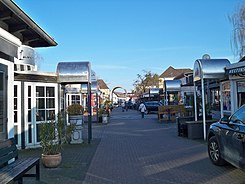
| Street in Wolfsburg | |
| Kaufhof from west to east | |
| Basic data | |
| place | Wolfsburg |
| District | City center |
| Created | 1949 |
| Newly designed | 1978 |
| Connecting roads | Schillerstrasse, Kaufhofpassage |
| Cross streets | Kantallee |
| use | |
| User groups | Pedestrian traffic , car traffic (feeder) |
| Road design | Concrete pavement, natural stone pavement, asphalt |
| Technical specifications | |
| Street length | 120 m |
The Kaufhof is a street in the Stadtmitte district in Wolfsburg . It was designed as a shopping street and is now considered a “pub mile”.
history
After the Second World War, there were some makeshift shops in the Schachtweg area - not far from the main entrance to the Volkswagen factory . Originally, no shopping street was planned when the city was built, but city planner Hans Bernhard Reichow approved the plan to build the Kaufhof in a vacant lot within the “Höfe”, a residential area built around 1940 close to the center. After the currency reform , the street was opened with around 20 shops in 1949. When Porschestrasse was built in the early 1950s, most of the stores moved there. They were replaced by inns. In 1978 the Kaufhof at the entrance to Schillerstrasse was completed. Since then, the entrance has been formed by a series of round arches. Most of the houses in the Kaufhof were also given small, arched porches.
From March 21 to April 16, 2020, the Kaufhof was closed to visitors due to the COVID-19 pandemic in Germany .
Plant, traffic and structures
The Kaufhof runs in a west-east direction. It begins at the indoor pool - culture on Schachtweg and after about 20 meters leads over Kantallee to Schillerstrasse. The western section is paved, the main section is paved. The single-storey houses from the time the street was built face each other in the section between Kantallee and Schillerstraße and create a wider space between the narrowed ends of the street. Some of them have stems and “almost look like solid market stalls”. In addition to restaurants and bars, there are small retail businesses and a craft business.
A chain of round arches - the middle, largest round arch spans the street - forms the end of Schillerstraße, where the “Kaufhof” bus stop, which is served by numerous WVG lines, is located near the Kaufhof . The continuation of the Kaufhof towards Porschestrasse is called the Kaufhofpassage.
literature
- Nicole Froberg, Ulrich Knufinke, Susanne Kreykenboom: Wolfsburg. The architecture guide. Braun Publishing, Berlin 2011, ISBN 978-3-03768-055-1 , p. 56.
Web links
Individual evidence
- ↑ Kaufhof "Laufhof". Aller newspaper from September 7, 1949. In: 50 years of Wolfsburg in the mirror of the press. City of Wolfsburg, Wolfsburg 1988.
- ^ A b Nicole Froberg, Ulrich Knufinke, Susanne Kreykenboom: Wolfsburg. The architecture guide. Braun Publishing, Berlin 2011, ISBN 978-3-03768-055-1 , p. 56.
- ↑ Allerpark, Schillerteich and Kaufhofpassage are now closed. In: Wolfsburger Nachrichten. Edition of March 21, 2020.
- ↑ Markus Kutscher: Allerpark and Schillerteich released again from today. In: Wolfsburger Nachrichten. Edition of April 17, 2020.
Coordinates: 52 ° 25 ′ 25 ″ N , 10 ° 47 ′ 5 ″ E

