Kavali (India)
| Kavali | ||
|---|---|---|
|
|
||
| State : |
|
|
| State : | Andhra Pradesh | |
| District : | Sri Potti Sriramulu Nellore | |
| Location : | 14 ° 55 ' N , 79 ° 59' E | |
| Height : | 20 m | |
| Residents : | 82,336 (2011) | |
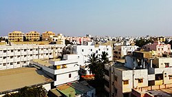
| view on the city | ||
Kavali is a city in the Indian state of Andhra Pradesh .
The city is part of the Sri Potti Sriramulu Nellore District . Kavali has the status of a municipality . The city is divided into 11 wards (constituencies).
Demographics
The city's population is 82,336 according to the 2011 census. 90,099 people live in the metropolitan region.
Infrastructure
A train station connects the city with the national rail network. A national highway also runs through the city.

