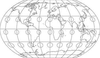
Kawraiski VII projection

Distortions of the Kawraiski VII projection illustrated with the Tissot indicatrix
The Kawraiski VII projection is a map network draft for the entire surface of the earth published by Vladimir Kawraiski in 1939 .
It represents a compromise between surface and angular accuracy and, in more recent studies, achieves values that are comparable to the angle-triple projection , which is better known in the west .
Formulas
The projection of the coordinates on the map is defined as:
Individual evidence
- ↑ Frank Canters, Roel Deknopper and William De Genst: A new approach for designing orthophanic world maps. (PDF; 384 kB)
- ^ David M. Goldberg, J. Richard Gott: Large-Scale Distortions in Map Projections. (PDF; 2.8 MB)
literature
- John Parr Snyder: Flattening the Earth: Two Thousand Years of Map Projections. Chicago 1993, 201.
Web links
Commons : Kawraiski VII projections - collection of images, videos and audio files


