Kishau dam
| Kishau dam (planned) | |||||||||
|---|---|---|---|---|---|---|---|---|---|
|
|||||||||
|
|
|||||||||
| Coordinates | 30 ° 45 ′ 0 ″ N , 77 ° 42 ′ 16 ″ E | ||||||||
| Data on the structure | |||||||||
| Construction time: | planned: 2015–2023 | ||||||||
| Height above foundation level : | 236 m | ||||||||
| Building volume: | 9,500,000 m³ | ||||||||
| Crown length: | 680 m | ||||||||
| Power plant output: | 600 MW | ||||||||
| Data on the reservoir | |||||||||
| Water surface | 21.7 km² | ||||||||
| Storage space | 1810–2400 million m³ | ||||||||
| Design flood : | 23 019 m³ / s | ||||||||
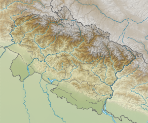
The Kishau Dam on the Tons , a tributary of the Yamuna , is a large dam project in India on the border between the states of Himachal Pradesh and Uttarakhand .
The dam is mainly used for irrigation, drinking water supply and electricity generation. It is located near Sambar Khera, 30 km from Dakpathar and 60 km from Dehradun on the border of the districts of Dehradun and Sirmaur .
The barrier structure is a 236 m high concrete gravity dam . According to other, unreliable information, it should be an earth and stone embankment dam. There are also contradicting data, according to which the height of the Kishau dam above the former river bed (or above the foundation bed) should be 253 m. There are also very different data for the memory contents, ranging from 1233 to 1324 and 1810 to 2400 million cubic meters.
The hydroelectric power station has at a drop height of 187.5 m four turbines with 150 MW, which together produce a power of 600 MW. Half of the water is used to irrigate 970.76 km² of agricultural land via the Eastern Yamuna Canal and the other half to supply the Union Territory of Delhi with drinking water. The project is owned by the Uttarakhand government. The cost of the entire project was estimated at 344 million rupees in 1996 and 356 million in 1998 .
See also:
