Sirmaur (district)
| Sirmaur District सिरमौर जिला |
|
|---|---|

|
|
| State | Himachal Pradesh |
| Administrative headquarters : | Close to |
| Area : | 2825 km² |
| Residents : | 529,855 (2011) |
| Population density : | 188 inhabitants / km² |
| Website : | hpsirmaur.nic.in |
The district of Sirmaur ( Hindi : सिरमौर जिला ) is a district of the Indian state of Himachal Pradesh . The district administration is based in Nahan .
geography
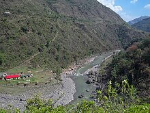
The Sirmaur district is located in the extreme southeast of Himachal Pradesh in the southern foothills of the Himalayas . Neighboring districts are Shimla in the north and Solan in the west. In the south the district borders on Haryana , in the east on Uttarakhand . The area of the district Sirmaur is 2825 km². The river Giri flows through the district in an easterly direction and divides it into a northern and a southern part - Giripar and Giriwar .
Administrative division
The district of Sirmaur is divided into the following Tehsils : Nahan, Renuka, Shillai, Rajgarh, Pachhad and Paonta Sahib.
population
According to the 2011 census, the Sirmaur district has 529,855 inhabitants. The population density is 188 people per square kilometer, above the state average.
history
The princely state of Sirmur existed until 1956 .
Web links
Individual evidence
Big text
Coordinates: 30 ° 39 ' N , 77 ° 27' E
