Kullu (District)
| Kullu District कुल्लू जिला |
|
|---|---|

|
|
| State | Himachal Pradesh |
| Administrative headquarters : | Kullu |
| Area : | 5,503 km² |
| Residents : | 437,903 (2011) |
| Population density : | 80 people / km² |
| Website : | hpkullu.nic.in |
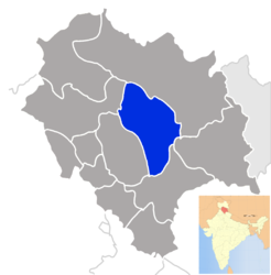
The district of Kullu ( Hindi : कुल्लू जिला ) is a district of the Indian state of Himachal Pradesh . The district administration is based in Kullu .
geography
The district of Kullu is centrally located in the state of Himachal Pradesh south of the main ridge and on the foothills of the Himalayas . Neighboring districts are Kangra in the west, Mandi in the southwest, Shimla in the south, Kinnaur in the east and Lahaul and Spiti in the north. The area of the district of Kullu is 5,503 square kilometers. In the west of the district is the Kullutul on the upper reaches of the Beas with the settlement centers of Manali , Kullu and Bhuntar . The river valleys of the left-hand Beas tributaries Parbati , Sainj and Tirthan form further settlement areas in the district. The Satluj runs along the southern border of the district . In the northeast of Kullu, the mountain ridges extend south of the main Himalayan ridge. The Great Himalayan National Park is located there . The Pir Panjal mountain range runs to the north-west of Kullu .
Administrative division
The Kullu District is divided into the following Tehsils : Kullu, Nirmand, Banjar and Manali.
population
According to the 2011 census, the Kullu district has 437,903 inhabitants. The population density is 80 people per square kilometer, below the state average.
Web links
Individual evidence
Big text
Coordinates: 31 ° 55 ' N , 77 ° 13' E
