Pir Panjal
| Pir Panjal | |
|---|---|
|
Pir Panjal Mountains |
|
| Highest peak | Indrasan ( 6221 m ) |
| location |
Jammu and Kashmir , Himachal Pradesh ( India ), Asad Kashmir ( Pakistan ) |
| part of | Himalayas |
| Coordinates | 33 ° 13 ' N , 75 ° 57' E |
|
Satellite image of the Kashmir Valley. The snow-covered Pir Panjal separates the high valley in the west and south from the plain |
|
|
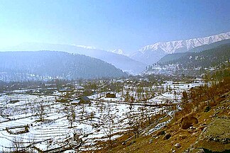
View to Pir Panjal |
|
The Pir Panjal is a mountain group in the Front Himalaya .
It runs over a length of 440 km from east-southeast to west-northwest through the Indian state of Himachal Pradesh , the Indian- administered area of Jammu and Kashmir and the Pakistani- administered Asad Kashmir . The average altitude ranges from 1400 m to 4100 m . The Pir Panjal is the largest chain in the Front Himalayas . East of Manali it separates from the Himalayas and forms the watershed between the Beas and Ravi rivers on one side and the Chenab on the other. Further to the west, the Chanab cuts through the mountains. The Pir Panjal runs south and west of the Kashmir valley and ends at the river valley of the Nilam . The Jhelam , which drains the Kashmir Valley, is the second river to cut through the Pir Panjal ridge. The mountain town of Murree and the mountains of Galliat are also in this chain.
summit
The Deo Tibba ( 6001 m ) and the Indrasan ( 6221 m ) are important peaks in the east of the Pir Panjal. The hill station of Gulmarg in Kashmir is also in this chain.
Passports
The Pir Panjal Pass is west of Srinagar.
The Banihal Pass is located in the headwaters of the Jhelam (Vitasta) at the southern end of the Kashmir Valley. Banihal and Qazigund are at either end of the pass.
The Sinthan Pass connects Jammu and Kashmir with the Kishtwar region .
The Pir ki Gali connects the Kashmir Valley with Rajouri and Punch via the Mughal Road . The Pir ki Gali is the highest point of the Mughal Road and is located in the southwest of the Kashmir Valley. The place at the foot of Pir Ki Gali is Shupian .
The Munawar Pass lies in the north of the Pir ki Gali near Rajouri.
Munawar Pass was the site of some of the heaviest fighting during Operation Gibraltar at the start of the Second Indo-Pakistani War . The pass was held by Major Malik Munawar Khan Awan , who later took the Rajouri garrison. The pass was named after him by the locals.
The Rohtang Pass is located in the east of Pir Panjal and connects Manali in Kullu valley with Keylong in Lahaultal .
The Haji-Pir Pass in the western part of the Pir Panjal along the road from Punch to Uri is in the Pakistani-administered part of Kashmir. The pass and the strategically important road were captured by the Indian Army in 1947 in the First Indo-Pakistani War .
tunnel
Old Banihal road tunnel
A 2.5 km long tunnel through the Pir Panjal under the Banihal Pass connects Banihal with Qazigund. Construction began in early 1950 and opened in December 1956. The tunnel, which creates a snow-free connection at an altitude of 2100 m , was named after the first Prime Minister of India Jawahar Tunnel . Designed for 150 vehicles a day, it is now used by more than 7000 vehicles. Therefore a new tunnel was planned further down the mountain.
New Banihal road tunnel
Construction on the new 8.45 km long Banihal-Qazigund Tunnel began in 2011. Since it is lower than the old tunnel, it is less prone to avalanches.
Rohtang road tunnel
The Rohtang Pass Highway Tunnel is being built just west of the Rohtang Pass along the Leh-Manali Highway . With a length of 8.8 km, it will be the longest road tunnel in India. It will shorten the distance between Manali and Keylong by around 60 km. The tunnel is at an altitude of 3100 m and the pass at 3978 m .
Banihal railway tunnel
The Pir Panjal Railway Tunnel is 11.215 km long. It connects Quazigund and Banihal and is part of the Udhampur –Srinagar– Baramulla railway line. The tunnel went into operation on June 26, 2013. It is India's longest and Asia's third longest railway tunnel.
Individual evidence
- ↑ Home ministry chalks out plan to settle Kashmiri Pandits
- ↑ Pir Panjal Range (mountain system, Asia) - Britannica Online Encyclopedia
- ↑ Beacon Light in the Tunnel ( Memento from September 1, 2012 in the Internet Archive )
- ↑ Passages of employment to Srinagar's denizens. In: The Hindu
- ^ India's longest railway tunnel unveiled in Jammu & Kashmir . In: The Times of India , October 14, 2011.


