Mandi (district)
| Mandi District मंडी जिला |
|
|---|---|

|
|
| State | Himachal Pradesh |
| Administrative headquarters : | Mandi |
| Area : | 3950 km² |
| Residents : | 999,777 (2011) |
| Population density : | 253 inhabitants / km² |
| Website : | himachal.gov.in/index.php?lang=1&dpt_id=199 |
The Mandi district ( Hindi : मंडी जिला ) is a district in the Indian state of Himachal Pradesh . The district administration is based in Mandi .
geography
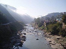
The Mandi District is located in the center of Himachal Pradesh in the Upper Himalayas . Neighboring districts are Kullu in the northeast, Kangra in the northwest, Hamirpur and Bilaspur in the west and Solan and Shimla in the south. The Sutlej flows along the southern district boundary . The Beas crosses the district. Its right tributary, the Uhl, drains the northeast of the district. The area of the Mandi district is 3950 km².
population
According to the 2011 census, the Mandi district has 999,777 inhabitants. The population density is 253 people per square kilometer, above the state average.
history
The princely state of Mandi existed until 1956.
Web links
Individual evidence
Big text
Coordinates: 31 ° 41 ′ N , 76 ° 57 ′ E
