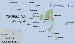
Kitava
| Kitava | ||
|---|---|---|
| Kitava is the easternmost of the Trobriand Islands | ||
| Waters | Solomon Lake | |
| Archipelago | Trobriand Islands | |
| Geographical location | 8 ° 37 '20 " S , 151 ° 20' 4" E | |
|
|
||
| length | 7.1 km | |
| width | 4.2 km | |
| surface | 15 km² | |
| Highest elevation | 142 m | |
| Residents | 2907 (2000) 194 inhabitants / km² |
|
| main place | Okabulula | |
Kitava is the easternmost island of the Trobriand Islands in Papua New Guinea . It is located 17.8 km east of the main island of Kiriwina . A good 300 meters west of the western tip is the uninhabited and only four hectare large side island of Uratu .
In 1989, 2,300 residents were named. At the 2000 census there were 2,907, which were distributed over the following eight villages and two separately recorded schools in three statistical census districts ( wards ):
By far the largest village is Okabulula (officially Okabulula 1,2 and 3 ) on the northern tip of the island, with 1,063 inhabitants. At this point, a village called Bomapou is proven to be the location of the school and the earlier mission.
![]() Map with all coordinates: OSM | WikiMap
Map with all coordinates: OSM | WikiMap
| Census Unit Number |
Surname | Ward | households | Population male |
Population female |
population total |
Coordinates |
|---|---|---|---|---|---|---|---|
| 001 | Kumwagea | 27 Kumwagea | 107 | 251 | 247 | 498 | 8.6313 ° S , 151.3227 ° O |
| 401 | Kitava Community School | 27 Kumwagea | 9 | 20th | 23 | 43 | 8.6166 ° S , 151.3966 ° O |
| 001 | Lalela | 28 Lalela | 148 | 363 | 338 | 701 | 8.6439 ° S , 151.3278 ° O |
| 002 | Lalak | 28 Lalela | 30th | 78 | 71 | 149 | 8.6432 ° S , 151.3375 ° O |
| 003 | Taregasi | 28 Lalela | 11 | 32 | 25th | 57 | 8.6317 ° S , 151.3521 ° O |
| 004 | Kimutu | 28 Lalela | 8th | 25th | 23 | 48 | 8.6393 ° S , 151.3426 ° O |
| 001 | Okabulula 1,2 and 3 | 29 Okabulula | 204 | 542 | 521 | 1063 | 8.6054 ° S , 151.352 ° O |
| 002 | Wapaya | 29 Okabulula | 42 | 113 | 105 | 218 | 8.6148 ° S , 151.3297 ° O |
| 003 | Kudeuli | 29 Okabulula | 17th | 62 | 48 | 110 | 8.6222 ° S , 151.3267 ° O |
| 401 | Okabulula Community School | 29 Okabulula | 3 | 11 | 9 | 20th | 8.6054 ° S , 151.352 ° O |
The island reaches a height of 142 meters. The island's inhabitants, also called Kitava, are known for their natural diet and lifestyle.
health
After the Kitava study by Steffan Lindenberg none of the so-called are lifestyle diseases present.
nutrition
The Kitava diet has a very high carbohydrate content (approx. 69% of the energy content ). The main food is root vegetables (yams, sweet potatoes, taro and tapioca). In addition, fruits (coconut, bananas, papaya, pineapple, guava, watermelons and pumpkin), some vegetables and a little fish are eaten.
Individual evidence
- ^ 2000 Census, Milne Bay Province, Kiriwina-Goodenough District
- ↑ Megaliths, Stones and Bwala on Kitava, Trobriand Islands, Papua. CD Ollier, DK Holdsworth, G. Heers. Archeology & Physical Anthropology in Oceania, Vol. 8, No. 1 (Apr., 1973), pp. 41-50
- ↑ PUB. (ENROUTE) SAILING DIRECTIONS 2011 164 NEW GUINEA (PDF; 4.1 MB) Prepared and published by the NATIONAL GEOSPATIAL-INTELLIGENCE AGENCY Springfield, Virginia TWELFTH EDITION
- ↑ Kitava Study ( Memento of the original from December 7, 2013 in the Internet Archive ) Info: The archive link was inserted automatically and has not yet been checked. Please check the original and archive link according to the instructions and then remove this notice.
- ^ Diet and health of the Kitava compared to the Maasai

