Konens Høj

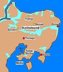
The Konens Høj is a natural hill from the flat area west of Stump Lake in southern Djursland in Jutland in Denmark stands. The flat terrain was part of a fjord in the Atlantic , the remainder of which is Stubbe Lake. In 1962 a Stone Age settlement layer was discovered in an exploratory trench and between 1963 and 1965 large quantities of pottery shards and flint from the early Neolithic on an area of 350 m² in and around this layer . The result of the C14 dating of a sample from a coal layer gave the date 3310 BC. BC This is the oldest Neolithic settlement in Denmark. In the course of the investigation, a grave was found on a leveled area that had been dug down to the natural ground.
The earth grave
The grave floor was a horizontal, rectangular, almost west-east oriented limestone pavement with a size of 3.5 × 0.8 m. On each long side there were two parallel rows of stones with different regularities and stacks of stones were found at the narrow ends of the paving. When the pavement was removed, oval pits were discovered at both ends, with their long axes transverse to the pavement. Their length corresponded to the width of the pavement. The east pit was about 1.2 m below the grave floor, while the west pit was about 1.0 m deep. Both sides had flat wedges. The pits can only be understood as foundation pits for wooden gables, which closed at the ends the grave space that had the shape of later huts for the dead . Presumably a ridge beam connected the two gables. The parallel rows of stones on the side of the pavement probably supported the roof, which rested on the inner row and was held in place by the outer one. No traces of a roof were found between the rows. That could mean that the roof wasn't very compact. Fragments of charcoal lay in the sand that covered the pavement. A C14 analysis showed a date of 2900 BC. Chr.
There is nothing to indicate that the grave was covered by a hill. It is a relatively rare earth grave from the early Neolithic. The objects found have a cultural connection to earlier finds from this time - the pot is z. B. the finds in nearby Barkjær almost parallel. The C14 date seems surprisingly early, but a corresponding date also applies to the English grave of Wayland's Smithy , with an identical construction. It differs in that it is a community grave for at least 14 people without grave goods and that it was covered by a small long mound.
Finds
At the western end of the grave, enamel and poorly preserved bone fragments lay on the pavement . A deformed copper plate was found under the largest - a forearm fragment. Their length was 59 mm, the width 26 mm, and the thickness 0.8 mm. It has a slight corrugation along the long sides. Somewhat south of the bone fragments, a spiral ring made of a copper band about 0.3 mm thick and 10 mm wide was found, presumably a finger ring. Approximately in the middle of the grave was an hourglass-shaped piece of amber , which could be interpreted as a belt part from its shape and location in the grave. In the middle there is a groove that appears slightly worn. At the eastern end, a pot was found that had partially slipped into the recess of the nearby foundation pit. He refers the grave to the funnel cup culture (TBK). The decorated eyelet vessel is about 20 cm high. The body is smooth and gray-brown to dirty yellow. A fragmented piece of amber that sat between the hourglass-shaped amber and the pot was originally almost rectangular with rounded corners. Length 60 mm, width 42 mm, thickness 14 mm.
Despite the lack of skeletal material, the position of the skeleton can be determined. It was on the right side, facing south. One hand lies in front of the face (copper ring), the other either above or below the neck (bone fragment above the copper plate). Assuming that the hourglass-shaped piece of amber is a belt clasp, the corpse was buried clothed. No bone fragment is burned. When the burial roof was burnt, the fire must have been relatively small or the dead must have been covered with a thin layer of sand.
See also
literature
- Seweryn Rzepecki: The roots of megalitism in the TRB culture. Instytut Archeologii Uniwersytetu Łódźkiego, 2011, ISBN 978-83-933586-1-8 .
- Jürgen E. Walkowitz: The megalithic syndrome. European cult sites of the Stone Age (= contributions to the prehistory and early history of Central Europe. Vol. 36). Beier & Beran, Langenweißbach 2003, ISBN 3-930036-70-3 .
Coordinates: 56 ° 15 ′ 40.1 ″ N , 10 ° 40 ′ 8.7 ″ E