Koonga
| Koonga | |||
|
|||
| State : |
|
||
| Circle : |
|
||
| Coordinates : | 58 ° 35 ' N , 24 ° 9' E | ||
| Area : | 438 km² | ||
| Residents : | 1,260 (01.2010) | ||
| Population density : | 3 inhabitants per km² | ||
| Time zone : | EET (UTC + 2) | ||
| Community type: | former rural community | ||

|
|||
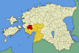
Koonga ( Koonga vald , German: Kokenkau ) is a former Estonian rural community in Pärnu County . In 2017 Koonga was incorporated into the rural community of Lääneranna .
1260 inhabitants lived in an area of 438 km² (as of January 1, 2010).
Koonga was about 40 km from Pärnu . The center was Koonga. The rural community also included the villages of Emmu, Hõbeda, Irta, Iska, Joonuse, Jänistvere, Järve, Kalli, Karinõmme, Karuba, Kibura, Kiisamaa, Kuhu, Kurese, Kõima, Lõpe, Maikse, Mihkli , Oidrätema, Nedrema, Nedrema, Paimvere, Palatu, Parasmaa, Peantse, Piisu, Pikavere, Rabavere, Salevere, Sookatse, Tamme, Tarva, Tõitse, Ura, Urita, Vastaba, Veltsa, Võitra, Võrungi and Õepa.
Koonga was well developed for hiking and cycling tours. The archaeological remains of an Estonian fortress from the 10th to 12th centuries, the so-called Soontagana maalinn , and the manor house of Oidremaa, which was built in the 19th century by the Baltic German family von Lilienfeldt, were worth seeing .
Web links
- Tourism in Koonga

