La Platte Mare
The remains of two small dolmens or stone boxes from La Platte Mare are on the grounds of the L'Ancresse Golf Club, about 100 m north of Les Fouaillages in Vale in the north of the Channel Island of Guernsey .
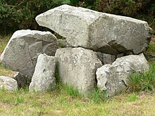
The megalithic box / chamber on the west side consists of seven upright stones and an overlying capstone. However, today's floor plan is misleading as the original order has been disrupted. Originally it seems to have been a polygonal stone box. It is surrounded by a round hill about 5.0 m in diameter with a rim of slabs and rocks. The layout of the type is known as the "cist-in-circle" memorial. On the side of the northern stone there is an unusual feature, a curved row of twelve bowls , seven of which are visible; the others are in the ground. This shows that this stone, once probably the second capstone, was moved to the wrong place years ago. The bowls are the only example of petroglyphs on the island (apart from a figure on the capstone of Le Dehus ) .
A few meters away are the remains of the second box or chamber.
The megalithic complex was excavated between 1837 and 1840 by Frederick Corbin Lukis (1788–1871). The finds consisted of a cup and Late Neolithic pottery, polished stone axes two and a arrowhead from flint . During the excavations at Les Fouaillages in 1981, the opportunity was taken to re-examine the chamber and the surrounding hill. The chamber had been thoroughly emptied, but most of the mound was undisturbed and pottery from the Bell Beaker Culture from the Early Bronze Age was found. The box therefore dates from around 2500 to 1800 BC. Chr.
The Dolmen La Varde is also nearby .
See also
literature
- Ian Kinnes: Les Fouaillages and the megalithic monuments of Guernsey . Aldernay: Ampersand Press in association with the States of Guernsey Ancient Monuments Committee 1983.
Web links
Coordinates: 49 ° 29 '53.1 " N , 2 ° 32' 14.5" W.
