Lake Brownworth
| Lake Brownworth | ||
|---|---|---|

|
||
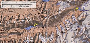
| Brownworth Lake (top right) on a map of the Wright Valley | ||
| Geographical location | Wright Valley , Victoria Land , East Antarctica | |
| Tributaries | Upper Wright Glacier , Onyx River | |
| Drain | Lower Wright Glacier , Onyx River | |
| Data | ||
| Coordinates | 77 ° 26 ′ 0 ″ S , 162 ° 45 ′ 0 ″ E | |
|
|
||
The Lake Worth Brown is a meltwater lake in East Antarctic Victoria Land . It is located immediately west of the Lower Wright Glacier at the eastern end of the Wright Valley .
The United States Geological Survey mapped the lake using its own surveys and using aerial photographs by the United States Navy between 1956 and 1960. The Advisory Committee on Antarctic Names named it in 1972 after the American topography engineer Frederick S. Brownworth Jr. (1926–1996) who participated in several research campaigns in Antarctica for the survey and from which aerial photographs of the Antarctic dry valleys including this lake from the years 1970 to 1971 are taken.
Web links
- Lake Brownworth in the Geographic Names Information System of the United States Geological Survey (English)
- Lake Brownworth on geographic.org (English)
