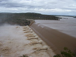
Lake Dalrymple (Queensland)
| Lake Dalrymple Burdekin Falls Dam |
|||||||||
|---|---|---|---|---|---|---|---|---|---|
| Burdekin Falls Dam | |||||||||
|
|||||||||
|
|
|||||||||
| Coordinates | 20 ° 38 '37 " S , 147 ° 8' 17" O | ||||||||
| Data on the structure | |||||||||
| Construction time: | 1984-1987 | ||||||||
| Height above the river bed : | 8.3 | ||||||||
| Height of the structure crown: | 37 m | ||||||||
| Crown length: | 876 m | ||||||||
| Data on the reservoir | |||||||||
| Altitude (at congestion destination ) | 158 m | ||||||||
| Water surface | 220 km² | ||||||||
| Reservoir length | 20 km | ||||||||
| Reservoir width | 30 km | ||||||||
| Total storage space : | 1.86 billion m³ | ||||||||
The Burdekin Dam is a dam in the east of the Australian state of Queensland during the Burdekin River .
The surface area at full damming is 220 km², the damming volume 1.86 billion m³ and the average depth 8.3 m. The height of the dam is 37 m. This makes Lake Dalrymple the largest reservoir in Queensland.
history
Construction of the Burdekin Falls dam began in 1984 and was completed in 1987. After the rainy season in 1988, Lake Dalrymple was completely filled for the first time. The construction work was carried out by Leighton Holdings .
use
The reservoir is used to supply drinking water to the cities of Townsville and Thuringowa , and to irrigate 103,000 km² of agricultural land up to 200 km from the coast. On the irrigated areas z. B. grown sugar cane , cotton and rice .
The lake is also used for water sports and fishing. However, there is only one slipway for boats near the dam and the considerable cloudiness of the water often makes boating dangerous, as underwater rocks cannot be seen.

