Lentzweiler
|
Lentzweiler ( German ) Lenzweiler ( lux. ) Lentzweiler ( French ) Wintger municipality
|
||
|---|---|---|
| Coordinates : | 50 ° 4 ′ N , 5 ° 58 ′ E | |
| Postal code : | 9761 | |
|
Location of Lentzweiler in Luxembourg
|
||
|
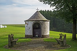
Wayside chapel
|
||
Lentzweiler ( Luxembourgish Lenzweiler ) is a village in the municipality of Wintger , canton of Clervaux in the Grand Duchy of Luxembourg .
location
Lentzweiler is located in the Ösling on the national road 18. In the southeast, an industrial area borders directly on the place. Neighboring towns Rümlingen in the north, Eselborn in the east and Deiffelt and Stockem in the west.
General
Lentzweiler is one of the smaller districts of the municipality of Wintger.
Web links
Commons : Lentzweiler - collection of images, videos and audio files

