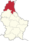
Canton of Clervaux
| map | |
|---|---|
| Basic data | |
| State : | Luxembourg |
| LAU 1: | 05 |
| ISO 3166-2 : | LU-CL |
| Administrative headquarters: | Clervaux |
| Surface: | 331.75 km² ranked 1 of 12 |
| Residents: | 18,436 (January 1, 2019) Rank 10 of 12 |
| Population density : | 56 inhabitants per km² |
Coordinates: 50 ° 3 ' N , 6 ° 0' E
The canton of Clervaux is the northernmost canton of the Grand Duchy of Luxembourg . It borders Belgium to the north and west , the German state of Rhineland-Palatinate to the east and the cantons of Wiltz , Diekirch and Vianden to the south . It is the largest of the 12 cantons in Luxembourg.
Until the abolition of the Luxembourg districts on October 3, 2015, the canton belonged to the Diekirch district .
Administrative division
The canton of Clervaux comprises five municipalities (population as of January 1, 2019).
-
Clervaux (5340), educated on December 5, 2011
- Clervaux ,
- Heinerscheid and
- Munshausen
- Parc Hosingen (3591), formed on January 1st, 2012
- Ulflingen (3201)
- Weiswampach (1912)
- Wintger (4392)
Individual evidence
- ↑ STATEC Luxembourg - Population par canton et commune 1821–2019 (French)
- ↑ From Parliament: The districts are abolished. In: Luxemburger Wort . July 7, 2015, accessed July 3, 2019 .
Web links
Commons : Canton of Clervaux - Collection of images, videos and audio files
