Ludwig Scholz Bridge
Coordinates: 49 ° 25 ′ 21 ″ N , 11 ° 2 ′ 15 ″ E
| Ludwig Scholz Bridge | ||
|---|---|---|
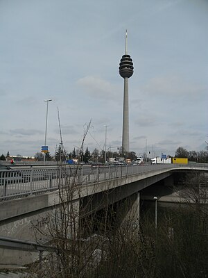
| View towards Schweinauer Hauptstrasse on the telecommunications tower | ||
| Convicted | Road traffic pedestrians bicycle traffic |
|
| Subjugated | Main-Danube Canal | |
| place | Nuremberg | |
| overall length | 476 m | |
| location | ||
|
|
||
The Ludwig-Scholz-Brücke is a bridge structure in Nuremberg , which represents both a section of federal highway 2 and federal highway 14 . It is the southern continuation of Schweinauer Hauptstraße to the fork in Ansbacher (B14) and Weißenburger Straße (B2) and has been named in honor of the former mayor of Nuremberg (1996–2002) Ludwig Scholz (1937–2005) since 2009 .
The bridge represents the connection between the district of Hohe Marter , located north of the Main-Danube Canal , and the district of Röthenbach , which is located to the south . Bus routes 35 and 65 use it for local public transport and is used for both car and foot traffic - and cycling. The bridge is also part of the entry and exit area of the Südwesttangenten exit Nürnberg-Schweinau / Röthenbach .
swell
- ↑ Bridge should be named after Ludwig Scholz on Mittelbayerische.de of November 25, 2008, accessed on December 2, 2017
- ↑ Bridge information on straßenweb.de, accessed on December 2, 2017

