Mêgo Aroug
| Mêgo Aroug | ||
|---|---|---|
| height | 1694 m | |
| location | Tadjoura , Djibouti | |
| Coordinates | 11 ° 50 '13 " N , 42 ° 14' 55" E | |
|
|
||
Mêgo Aroug is the second highest mountain in Djibouti with a height of 1694 m and the highest mountain that lies entirely on the national territory. It is located in the Tadjoura region in the northeast of the country near the border between Tadjoura and Dikhil in an extremely sparsely populated area.
geography
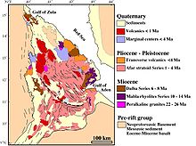
The mountain lies in the Afar triangle and is part of the ridge that separates the Afar depression in the northeast from the plains of Gaggadé or Ḏêr 'Êla and Habsou in the southwest. The depressions are branches of the East African Rift . Numerous bodies of water (mostly wadis ) run from the slopes of the mountain , leading north into the Mokolî Hîlou plain (475 m, ⊙ ), or south to Lake Assal . It rises high above the mountains of the surrounding area.

