Marble Arch Caves
| Marble Arch Caves
|
||
|---|---|---|
 |
||
| Location: | County Fermanagh near Florencecourt , Northern Ireland | |
|
Geographic location: |
54 ° 15 '34 " N , 7 ° 49' 20.1" W | |
|
||
| Geology: | lime | |
| Type: | Water cave | |
| Discovery: | 1895 | |
| Show cave since: | 1985 | |
| Lighting: | electric | |
| Website: | Homepage | |

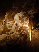
The Marble Arch Caves ( Irish Uaimheanna na hÁirse Marmair , German marble arch caves ) are located in the limestone area of County Fermanagh near Florencecourt in Northern Ireland . The southwest area is known for the Erne Lakes and for the sandstone plateau of the Cuilcagh Mountain, which raises the landscape up to about 670 m above sea level.
The weather is influenced by the Atlantic Ocean , which is only 56 km away . In the moorland of Cuilcagh Mountain, rain penetrates the peat and only reaches the rivers with a delay. During the summer the rivers are arid, but after heavy rainfall, a large amount of water flows down the slopes where the peat covers the sandstone below. From there you walk into the underground passages of the Marble Arch Caves, which have been explored since 1895 and were declared a European Geopark in 2004 . Some of the caves are accessed by boats.
- Marble Arch Caves