Maryland State Route 300

|
|
|---|---|
| map | |

|
|
| Basic data | |
| Overall length: | 13.55 mi / 21.81 km |
| Starting point: |
|
| End point: |
|
| County: | Queen Anne's County |
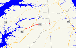
The Maryland State Route 300 (abbreviated MD 300 ) is a state highway in the US state of Maryland , which runs east-west direction.
The State Route begins on Maryland State Route 213 in Church Hill and ends after 14 miles at the Delaware border and then becomes Delaware State Route 300 .
course
After turning off MD 213 in the center of Church Hill town, the road runs on Sudlersville Road and joins Maryland State Route 19 after about 200 yards before exiting town for Sudlersville . After the junction with US Highway 301 , State Route 290 branches off to the north near Dudley's Chapel, which was built in the 18th century .
On Main Street in Sudlersville, the MD 300 meets Maryland State Route 313 and State Route 837, which is only 190 meters long . After passing Sudlersville Cemetery, the road leaves the town in an easterly direction and ends after a total of 22 kilometers at the border with the neighboring state of Delaware, where the road merges into Delaware State Route 300.
See also
Web links
- MDRoads: Routes 300-319 (English)