Maryland State Route 290

|
|
|---|---|
| map | |

|
|
| Basic data | |
| Overall length: | 17.20 mi / 27.68 km |
| Starting point: |
|
| End point: |
|
| Counties: |
Queen Anne's County Kent County |
The Maryland State Route 290 (short MD 290 ) is a state route in the US state of Maryland , which runs in a north-south direction.
The State Route begins on Maryland State Route 300 in Dudley Corners and ends after 17 miles in Sassafras on Maryland State Route 299 .
course
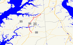
After the junction from State Route 300 north of Dudley's Chapel , the MD 290 runs north and crosses under the US Highway 301 on Dudley Corners Road . The road meets Maryland State Route 544 at Crumpton Cemetery south of the village of Crumpton . After passing the village, the MD 290 crosses the Chester River and uses the Maryland State Route 291 eastbound for a distance of about one kilometer before branching off towards Chesterville .
At the intersection with State Route 444 is the historic Chesterville Brick House . South of the village of Galena , the MD 290 and State Route 313 use a route for about two kilometers, but after the junction with Maryland State Route 213 it leaves the village again eastwards towards Sassafras. About one kilometer after crossing under US Highway 301 again, the road ends after a total of 28 kilometers at Maryland State Route 299 south of Sassafras.
See also
Web links
- MDRoads: Routes 280-299 (English)