
Maschteich
| Maschteich | ||
|---|---|---|

|
||
| View over the Maschteich to the New Town Hall | ||
| Geographical location | Hanover , Lower Saxony | |
| Data | ||
| Coordinates | 52 ° 21 '56.2 " N , 9 ° 44' 13.6" E | |
|
||
| surface | 2.6 ha | |
|
particularities |
artificially designed |
|

The Maschteich is an artificially created lake in the area of the Lower Saxony state capital Hanover in Germany .
history
The 2.6 hectare large bodies of water was in the years 1899 to 1900 as part of the on plans by Julius Trip scale Masch parks dug. The New City Hall of Hanover has been standing immediately north of the Maschteich since 1913 . The much larger Maschsee was created south of the Maschpark in the 1930s.
One of the paths in the Maschpark crosses the Maschteich by means of a bridge. Several art objects are placed in the Maschteich and on its bank in the park.
Maschteich on TV
Photos of the Maschteich with the New Town Hall in the background are used by several German television stations as background images for word contributions from the respective “ Studio Hannover”.
The bridge over the Maschteich made headlines in 2014 because of its railing, which was damaged by numerous locks .
Picture gallery

Bridge railing of the bridge over the Maschteich
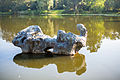
Sculpture by the artist Toni Stadler in the Maschteich
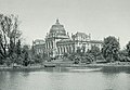
Provincial Museum Hannover am Maschteich (around 1900)


See also
Individual evidence
- ↑ Henrike Schwarz: The Maschpark. (pdf; 1.45 MB). State capital Hanover. Office for Green Spaces in collaboration with the Press and Information Office, accessed on December 15, 2015 .
- ↑ Bolt cutter separates hundreds of love vows. www.haz.de, January 28, 2015, accessed on August 26, 2020 .